Apremont geodata
Apremont (Hauts-de-France) is a populated place; located in France in Europe/Paris (GMT+2) time zone. With population of 861 people, there are 9985 cities with bigger population in this country. Compared to other cities in France, 84.7% of cities are located further ↓South; 50.7% of cities are located further ←West and 67.4% of cities have higher elevation than Apremont. Note1
Administrative division(s):
- Level 1: Hauts-de-France
- Level 2: Département de l'Oise
- Level 3: Arrondissement de Senlis
- Level 4: Apremont


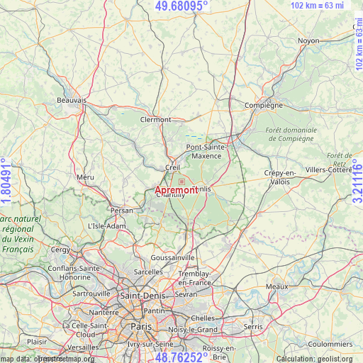
Apremont GPS coordinates[2]
49° 13' 25.932" North, 2° 30' 28.944" East
| Map corner | latitude | longitude |
|---|---|---|
| Upper-left | 49.68095°, | 1.80491° |
| Center: | 49.22387°, | 2.50804° |
| Lower-right: | 48.76252°, | 3.21116° |
| Map W x H: | 102.1×102.1 km | = 63.4×63.4mi |
| max Lat: | 51.07786° ⇑15.3% North |
| Apremont: | 49.22387° |
| min Lat: | ⇓84.7% South 41.3874° |
| min Long | Apremont | max Long |
| -5.08615° | 2.50804° | 9.52242° |
| W 50.7%⇐ | ⇒49.3% E |
Elevation
Elevation of Apremont is 84 m = 276 ft, and this is 109.7 m = 360 ft below average elevation for this country.
| Max E: |
2333 m = 7654 ft | 67.4% |
| Avg. | 193.7 m = 635 ft | |
| Apremont | 84 m = 276 ft | |
Min E: |
-1 m = -3 ft | 32.6% |
See also: France elevation on elevation.city.
Geographical zone
Apremont is located in North temperate zone (between Tropic of Cancer and the Arctic Circle). Distance of this North polar circle is 1928 km =1198 mi to North.| Distance of | km | miles | from Apremont |
|---|---|---|---|
| North Pole | 4533.9 | 2817.2 | to North |
| Arctic Circle | 1928 | 1198 | to North |
| Tropic Cancer | 2867.3 | 1781.7 | to South |
| Equator | 5473.2 | 3400.9 | to South |


Nearby cities:
15 places around Apremont: (largest is in red/bold)
• Aumont-en-Halatte
3.2 km =2 mi,  70°
70°
• Avilly-Saint-Léonard
4.1 km =2.5 mi,  143°
143°
• Chamant
7.5 km =4.7 mi,  93°
93°
• Chantilly
4.2 km =2.6 mi,  219°
219°
• Courteuil
3.2 km =2 mi,  145°
145°
• Creil
4 km =2.5 mi,  335°
335°
• Fleurines
6.7 km =4.2 mi,  54°
54°
• Montataire
6.4 km =4 mi,  307°
307°
• Nogent-sur-Oise
6 km =3.7 mi,  332°
332°
• Saint-Maximin
4 km =2.5 mi,  266°
266°
• Senlis
6 km =3.7 mi,  107°
107°
• Thiverny
6.1 km =3.8 mi,  300°
300°
• Verneuil-en-Halatte
6.3 km =3.9 mi,  10°
10°
• Villers-Saint-Paul
7.3 km =4.5 mi,  349°
349°
• Vineuil-Saint-Firmin
2.8 km =1.7 mi,  198°
198°
Sources, notices
• [Note1] Compared only with cities in France existing in our database
• [Src1] Map data: © OpenStreetMap contributors (CC-BY-SA)
• [Src2] Other city data from geonames.org with taken over terms of usage.
• [Src3] Geographical zone / Annual Mean Temperature by Robert A. Rohde @ Wikipedia
