Saint-Maurice-sur-Moselle geodata
Saint-Maurice-sur-Moselle (Grand Est) is a populated place; located in France in Europe/Paris (GMT+2) time zone. With population of 1,507 people, there are 6170 cities with bigger population in this country. Compared to other cities in France, 56.7% of cities are located further ↓South; 93.7% of cities are located further ←West and 94.3% of cities have lower elevation than Saint-Maurice-sur-Moselle. Note1
Administrative division(s):
- Level 1: Grand Est
- Level 2: Vosges
- Level 3: Arrondissement d’Épinal
- Level 4: Saint-Maurice-sur-Moselle
Current local time in Saint-Maurice-sur-Moselle:
02:49 AM, WednesdayDifference from your time zone: hours


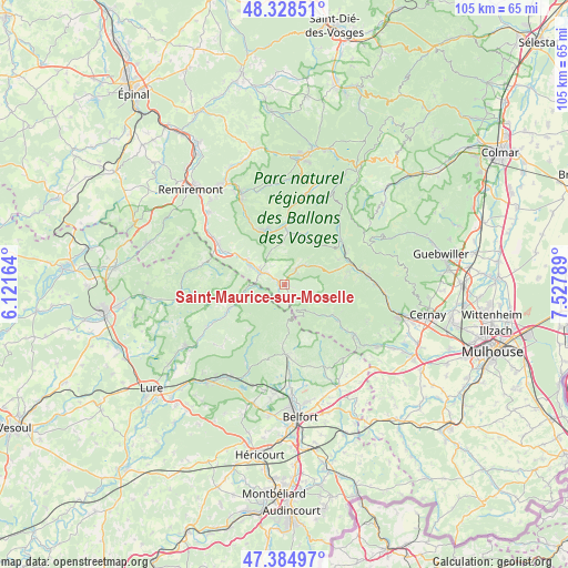
Saint-Maurice-sur-Moselle GPS coordinates[2]
47° 51' 32.004" North, 6° 49' 29.172" East
| Map corner | latitude | longitude |
|---|---|---|
| Upper-left | 48.32851°, | 6.12164° |
| Center: | 47.85889°, | 6.82477° |
| Lower-right: | 47.38497°, | 7.52789° |
| Map W x H: | 104.9×104.9 km | = 65.2×65.2mi |
| max Lat: | 51.07786° ⇑43.3% North |
| Saint-Maurice-sur-Moselle: | 47.85889° |
| min Lat: | ⇓56.7% South 41.3874° |
| min Long | Saint-Maurice-s | max Long |
| -5.08615° | 6.82477° | 9.52242° |
| W 93.7%⇐ | ⇒6.3% E |
Elevation
Elevation of Saint-Maurice-sur-Moselle is 553 m = 1814 ft, and this is 359.3 m = 1179 ft above average elevation for this country.
| Max E: |
2333 m = 7654 ft | 5.7% |
| Saint-Maurice-sur-Moselle | 553 m 1814 ft | |
| Avg. | 193.7 m = 635 ft | |
Min E: |
-1 m = -3 ft | 94.3% |
See also: France elevation on elevation.city.
Geographical zone
Saint-Maurice-sur-Moselle is located in North temperate zone (between Tropic of Cancer and the Arctic Circle). Distance of this North polar circle is 2079.8 km =1292.3 mi to North.| Distance of | km | miles | from Saint-Maurice-sur-Moselle |
|---|---|---|---|
| North Pole | 4685.7 | 2911.6 | to North |
| Arctic Circle | 2079.8 | 1292.3 | to North |
| Tropic Cancer | 2715.5 | 1687.3 | to South |
| Equator | 5321.4 | 3306.6 | to South |


Nearby cities:
15 places around Saint-Maurice-sur-Moselle: (largest is in red/bold)
• Bussang
3.5 km =2.2 mi,  36°
36°
• Cornimont
11.2 km =7 mi,  2°
2°
• Ferdrupt
10.1 km =6.3 mi,  301°
301°
• Fresse-sur-Moselle
3.5 km =2.2 mi, 303°
• Kirchberg
12.1 km =7.5 mi,  124°
124°
• Le Ménil
6 km =3.7 mi,  328°
328°
• Le Thillot
5.2 km =3.2 mi, 296°
• Lepuix
11 km =6.8 mi,  184°
184°
• Plancher-les-Mines
12.4 km =7.7 mi,  209°
209°
• Ramonchamp
7.3 km =4.5 mi, 302°
• Rimbach-près-Masevaux
10.1 km =6.3 mi,  109°
109°
• Saulxures-sur-Moselotte
10.8 km =6.7 mi,  337°
337°
• Servance
11.7 km =7.3 mi,  244°
244°
• Sewen
8.3 km =5.2 mi,  133°
133°
• Ventron
9.6 km =6 mi,  20°
20°
Sources, notices
• [Note1] Compared only with cities in France existing in our database
• [Src1] Map data: © OpenStreetMap contributors (CC-BY-SA)
• [Src2] Other city data from geonames.org with taken over terms of usage.
• [Src3] Geographical zone / Annual Mean Temperature by Robert A. Rohde @ Wikipedia
