Vénissieux geodata
Vénissieux (Auvergne-Rhône-Alpes) is a populated place; located in France in Europe/Paris (GMT+2) time zone. With population of 57,584 people, there are 92 cities with bigger population in this country. Compared to other cities in France, 70.9% of cities are located further ↑North; 76.3% of cities are located further ←West and 65.8% of cities have lower elevation than Vénissieux. Note1
Administrative division(s):
- Level 1: Auvergne-Rhône-Alpes
- Level 2: Département du Rhône
- Level 3: Arrondissement de Lyon
- Level 4: Vénissieux


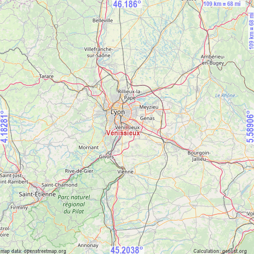
Vénissieux GPS coordinates[2]
45° 41' 49.416" North, 4° 53' 9.348" East
| Map corner | latitude | longitude |
|---|---|---|
| Upper-left | 46.186°, | 4.18281° |
| Center: | 45.69706°, | 4.88593° |
| Lower-right: | 45.2038°, | 5.58906° |
| Map W x H: | 109.2×109.2 km | = 67.9×67.9mi |
| max Lat: | 51.07786° ⇑70.9% North |
| Vénissieux: | 45.69706° |
| min Lat: | ⇓29.1% South 41.3874° |
| min Long | Vénissieux | max Long |
| -5.08615° | 4.88593° | 9.52242° |
| W 76.3%⇐ | ⇒23.7% E |
Elevation
Elevation of Vénissieux is 198 m = 650 ft, and this is 4.3 m = 14 ft above average elevation for this country.
| Max E: |
2333 m = 7654 ft | 34.2% |
| Vénissieux | 198 m 650 ft | |
| Avg. | 193.7 m = 635 ft | |
Min E: |
-1 m = -3 ft | 65.8% |
See also: Vénissieux elevation on elevation.city.
Geographical zone
Vénissieux is located in North temperate zone (between Tropic of Cancer and the Arctic Circle). Distance of this North polar circle is 2320.1 km =1441.6 mi to North.| Distance of | km | miles | from Vénissieux |
|---|---|---|---|
| North Pole | 4926 | 3060.9 | to North |
| Arctic Circle | 2320.1 | 1441.6 | to North |
| Tropic Cancer | 2475.1 | 1538 | to South |
| Equator | 5081 | 3157.2 | to South |


Nearby cities:
15 places around Vénissieux: (largest is in red/bold)
• Bron
5.1 km =3.2 mi,  24°
24°
• Corbas
3.5 km =2.2 mi,  158°
158°
• Feyzin
3.4 km =2.1 mi,  217°
217°
• Irigny
5.6 km =3.5 mi,  241°
241°
• La Mulatière
6.7 km =4.2 mi,  301°
301°
• Lyon
6.5 km =4 mi,  331°
331°
• Mions
6.4 km =4 mi,  126°
126°
• Oullins
6.4 km =4 mi,  287°
287°
• Pierre-Bénite
4.8 km =3 mi,  278°
278°
• Saint-Fons
2.9 km =1.8 mi, 297°
• Saint-Genis-Laval
7.2 km =4.5 mi,  268°
268°
• Saint-Priest
4.5 km =2.8 mi,  90°
90°
• Sainte-Foy-lès-Lyon
7.6 km =4.7 mi, 302°
• Solaize
7.3 km =4.5 mi,  209°
209°
• Villeurbanne
7.7 km =4.8 mi,  356°
356°
Sources, notices
• [Note1] Compared only with cities in France existing in our database
• [Src1] Map data: © OpenStreetMap contributors (CC-BY-SA)
• [Src2] Other city data from geonames.org with taken over terms of usage.
• [Src3] Geographical zone / Annual Mean Temperature by Robert A. Rohde @ Wikipedia
