Feyzin geodata
Feyzin (Auvergne-Rhône-Alpes) is a populated place; located in France in Europe/Paris (GMT+2) time zone. With population of 9,539 people, there are 994 cities with bigger population in this country. Compared to other cities in France, 71.3% of cities are located further ↑North; 75.9% of cities are located further ←West and 71.2% of cities have lower elevation than Feyzin. Note1
Administrative division(s):
- Level 1: Auvergne-Rhône-Alpes
- Level 2: Département du Rhône
- Level 3: Arrondissement de Lyon
- Level 4: Feyzin


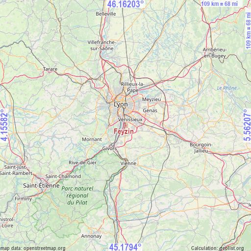
Feyzin GPS coordinates[2]
45° 40' 22.332" North, 4° 51' 32.184" East
| Map corner | latitude | longitude |
|---|---|---|
| Upper-left | 46.16203°, | 4.15582° |
| Center: | 45.67287°, | 4.85894° |
| Lower-right: | 45.1794°, | 5.56207° |
| Map W x H: | 109.3×109.3 km | = 67.9×67.9mi |
| max Lat: | 51.07786° ⇑71.3% North |
| Feyzin: | 45.67287° |
| min Lat: | ⇓28.7% South 41.3874° |
| min Long | Feyzin | max Long |
| -5.08615° | 4.85894° | 9.52242° |
| W 75.9%⇐ | ⇒24.1% E |
Elevation
Elevation of Feyzin is 225 m = 738 ft, and this is 31.3 m = 103 ft above average elevation for this country.
| Max E: |
2333 m = 7654 ft | 28.8% |
| Feyzin | 225 m 738 ft | |
| Avg. | 193.7 m = 635 ft | |
Min E: |
-1 m = -3 ft | 71.2% |
See also: France elevation on elevation.city.
Geographical zone
Feyzin is located in North temperate zone (between Tropic of Cancer and the Arctic Circle). Distance of this North polar circle is 2322.8 km =1443.3 mi to North.| Distance of | km | miles | from Feyzin |
|---|---|---|---|
| North Pole | 4928.7 | 3062.6 | to North |
| Arctic Circle | 2322.8 | 1443.3 | to North |
| Tropic Cancer | 2472.4 | 1536.3 | to South |
| Equator | 5078.3 | 3155.5 | to South |


Nearby cities:
15 places around Feyzin: (largest is in red/bold)
• Charly
5.7 km =3.5 mi,  241°
241°
• Corbas
3.4 km =2.1 mi,  99°
99°
• Irigny
2.8 km =1.7 mi,  270°
270°
• Marennes
7.1 km =4.4 mi,  144°
144°
• Oullins
6.1 km =3.8 mi,  318°
318°
• Pierre-Bénite
4.4 km =2.7 mi, 321°
• Saint-Fons
4 km =2.5 mi,  353°
353°
• Saint-Genis-Laval
5.7 km =3.5 mi,  296°
296°
• Saint-Priest
7.1 km =4.4 mi,  68°
68°
• Simandres
6 km =3.7 mi,  169°
169°
• Solaize
4 km =2.5 mi,  201°
201°
• Sérézin-du-Rhône
5.6 km =3.5 mi,  208°
208°
• Vernaison
4.6 km =2.9 mi,  232°
232°
• Vourles
6.8 km =4.2 mi,  256°
256°
• Vénissieux
3.4 km =2.1 mi,  37°
37°
Sources, notices
• [Note1] Compared only with cities in France existing in our database
• [Src1] Map data: © OpenStreetMap contributors (CC-BY-SA)
• [Src2] Other city data from geonames.org with taken over terms of usage.
• [Src3] Geographical zone / Annual Mean Temperature by Robert A. Rohde @ Wikipedia
