Lyon geodata
Lyon (Auvergne-Rhône-Alpes) is a seat of a first-order administrative division; located in France in Europe/Paris (GMT+2) time zone. With population of 472,317 people, there are 2 cities with bigger population in this country. Compared to other cities in France, 70.1% of cities are located further ↑North; 75.8% of cities are located further ←West and 60.7% of cities have lower elevation than Lyon. Note1
Administrative division(s):
- Level 1: Auvergne-Rhône-Alpes
- Level 2: Département du Rhône
- Level 3: Arrondissement de Lyon
- Level 4: Lyon


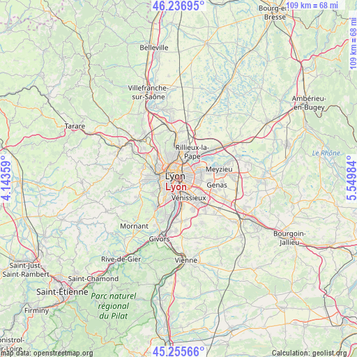
Lyon GPS coordinates[2]
45° 44' 54.456" North, 4° 50' 48.156" East
| Map corner | latitude | longitude |
|---|---|---|
| Upper-left | 46.23695°, | 4.14359° |
| Center: | 45.74846°, | 4.84671° |
| Lower-right: | 45.25566°, | 5.54984° |
| Map W x H: | 109.1×109.1 km | = 67.8×67.8mi |
| max Lat: | 51.07786° ⇑70.1% North |
| Lyon: | 45.74846° |
| min Lat: | ⇓29.9% South 41.3874° |
| min Long | Lyon | max Long |
| -5.08615° | 4.84671° | 9.52242° |
| W 75.8%⇐ | ⇒24.2% E |
Elevation
Elevation of Lyon is 173 m = 568 ft, and this is 20.7 m = 68 ft below average elevation for this country.
| Max E: |
2333 m = 7654 ft | 39.3% |
| Avg. | 193.7 m = 635 ft | |
| Lyon | 173 m = 568 ft | |
Min E: |
-1 m = -3 ft | 60.7% |
See also: Lyon elevation on elevation.city.
Geographical zone
Lyon is located in North temperate zone (between Tropic of Cancer and the Arctic Circle). Distance of this North polar circle is 2314.4 km =1438.1 mi to North.| Distance of | km | miles | from Lyon |
|---|---|---|---|
| North Pole | 4920.3 | 3057.3 | to North |
| Arctic Circle | 2314.4 | 1438.1 | to North |
| Tropic Cancer | 2480.8 | 1541.5 | to South |
| Equator | 5086.8 | 3160.8 | to South |


Nearby cities:
15 places around Lyon: (largest is in red/bold)
• Bron
5.3 km =3.3 mi,  101°
101°
• Caluire-et-Cuire
5.1 km =3.2 mi,  359°
359°
• Champagne-au-Mont-d’Or
6.7 km =4.2 mi,  319°
319°
• Francheville
6.6 km =4.1 mi,  258°
258°
• La Mulatière
3.5 km =2.2 mi,  229°
229°
• Oullins
4.9 km =3 mi,  218°
218°
• Pierre-Bénite
5.3 km =3.3 mi,  199°
199°
• Saint-Fons
4.4 km =2.7 mi,  173°
173°
• Saint-Genis-Laval
7.2 km =4.5 mi, 215°
• Sainte-Foy-lès-Lyon
3.8 km =2.4 mi,  244°
244°
• Tassin-la-Demi-Lune
4.6 km =2.9 mi,  279°
279°
• Vaulx-en-Velin
7.4 km =4.6 mi,  54°
54°
• Villeurbanne
3.2 km =2 mi, 52°
• Vénissieux
6.5 km =4 mi,  151°
151°
• Écully
6.1 km =3.8 mi,  298°
298°
Sources, notices
• [Note1] Compared only with cities in France existing in our database
• [Src1] Map data: © OpenStreetMap contributors (CC-BY-SA)
• [Src2] Other city data from geonames.org with taken over terms of usage.
• [Src3] Geographical zone / Annual Mean Temperature by Robert A. Rohde @ Wikipedia
