Sainte-Foy-lès-Lyon geodata
Sainte-Foy-lès-Lyon (Auvergne-Rhône-Alpes) is a populated place; located in France in Europe/Paris (GMT+2) time zone. With population of 21,893 people, there are 411 cities with bigger population in this country. Compared to other cities in France, 70.3% of cities are located further ↑North; 75.1% of cities are located further ←West and 61.3% of cities have lower elevation than Sainte-Foy-lès-Lyon. Note1
Administrative division(s):
- Level 1: Auvergne-Rhône-Alpes
- Level 2: Département du Rhône
- Level 3: Arrondissement de Lyon
- Level 4: Sainte-Foy-lès-Lyon


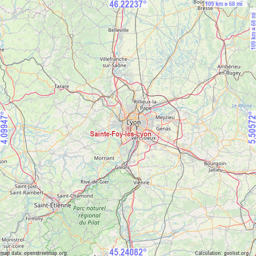
Sainte-Foy-lès-Lyon GPS coordinates[2]
45° 44' 1.5" North, 4° 48' 9.324" East
| Map corner | latitude | longitude |
|---|---|---|
| Upper-left | 46.22237°, | 4.09947° |
| Center: | 45.73375°, | 4.80259° |
| Lower-right: | 45.24082°, | 5.50572° |
| Map W x H: | 109.1×109.1 km | = 67.8×67.8mi |
| max Lat: | 51.07786° ⇑70.3% North |
| Sainte-Foy-lès-Lyon: | 45.73375° |
| min Lat: | ⇓29.7% South 41.3874° |
| min Long | Sainte-Foy-lès | max Long |
| -5.08615° | 4.80259° | 9.52242° |
| W 75.1%⇐ | ⇒24.9% E |
Elevation
Elevation of Sainte-Foy-lès-Lyon is 176 m = 577 ft, and this is 17.7 m = 58 ft below average elevation for this country.
| Max E: |
2333 m = 7654 ft | 38.7% |
| Avg. | 193.7 m = 635 ft | |
| Sainte-Foy-lès-Lyon | 176 m = 577 ft | |
Min E: |
-1 m = -3 ft | 61.3% |
See also: France elevation on elevation.city.
Geographical zone
Sainte-Foy-lès-Lyon is located in North temperate zone (between Tropic of Cancer and the Arctic Circle). Distance of this North polar circle is 2316.1 km =1439.2 mi to North.| Distance of | km | miles | from Sainte-Foy-lès-Lyon |
|---|---|---|---|
| North Pole | 4921.9 | 3058.3 | to North |
| Arctic Circle | 2316.1 | 1439.2 | to North |
| Tropic Cancer | 2479.2 | 1540.5 | to South |
| Equator | 5085.1 | 3159.7 | to South |


Nearby cities:
15 places around Sainte-Foy-lès-Lyon: (largest is in red/bold)
• Champagne-au-Mont-d’Or
6.8 km =4.2 mi,  352°
352°
• Chaponost
5.4 km =3.4 mi,  240°
240°
• Charbonnières-les-Bains
6.8 km =4.2 mi,  320°
320°
• Craponne
6.3 km =3.9 mi,  281°
281°
• Francheville
3 km =1.9 mi, 275°
• Irigny
6.9 km =4.3 mi,  167°
167°
• La Mulatière
1 km =0.6 mi,  129°
129°
• Lyon
3.8 km =2.4 mi,  64°
64°
• Oullins
2.2 km =1.4 mi, 170°
• Pierre-Bénite
3.8 km =2.4 mi,  153°
153°
• Saint-Fons
4.8 km =3 mi, 125°
• Saint-Genis-Laval
4.3 km =2.7 mi,  189°
189°
• Saint-Genis-les-Ollières
6.5 km =4 mi,  293°
293°
• Tassin-la-Demi-Lune
2.6 km =1.6 mi,  334°
334°
• Écully
4.9 km =3 mi,  336°
336°
Sources, notices
• [Note1] Compared only with cities in France existing in our database
• [Src1] Map data: © OpenStreetMap contributors (CC-BY-SA)
• [Src2] Other city data from geonames.org with taken over terms of usage.
• [Src3] Geographical zone / Annual Mean Temperature by Robert A. Rohde @ Wikipedia
