Oullins geodata
Oullins (Auvergne-Rhône-Alpes) is a populated place; located in France in Europe/Paris (GMT+2) time zone. With population of 25,592 people, there are 338 cities with bigger population in this country. Compared to other cities in France, 70.7% of cities are located further ↑North; 75.1% of cities are located further ←West and 63.6% of cities have lower elevation than Oullins. Note1
Administrative division(s):
- Level 1: Auvergne-Rhône-Alpes
- Level 2: Département du Rhône
- Level 3: Arrondissement de Lyon
- Level 4: Oullins


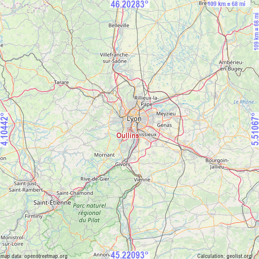
Oullins GPS coordinates[2]
45° 42' 50.544" North, 4° 48' 27.18" East
| Map corner | latitude | longitude |
|---|---|---|
| Upper-left | 46.20283°, | 4.10442° |
| Center: | 45.71404°, | 4.80755° |
| Lower-right: | 45.22093°, | 5.51067° |
| Map W x H: | 109.2×109.2 km | = 67.9×67.9mi |
| max Lat: | 51.07786° ⇑70.7% North |
| Oullins: | 45.71404° |
| min Lat: | ⇓29.3% South 41.3874° |
| min Long | Oullins | max Long |
| -5.08615° | 4.80755° | 9.52242° |
| W 75.1%⇐ | ⇒24.9% E |
Elevation
Elevation of Oullins is 187 m = 614 ft, and this is 6.7 m = 22 ft below average elevation for this country.
| Max E: |
2333 m = 7654 ft | 36.4% |
| Avg. | 193.7 m = 635 ft | |
| Oullins | 187 m = 614 ft | |
Min E: |
-1 m = -3 ft | 63.6% |
See also: France elevation on elevation.city.
Geographical zone
Oullins is located in North temperate zone (between Tropic of Cancer and the Arctic Circle). Distance of this North polar circle is 2318.2 km =1440.5 mi to North.| Distance of | km | miles | from Oullins |
|---|---|---|---|
| North Pole | 4924.1 | 3059.7 | to North |
| Arctic Circle | 2318.2 | 1440.5 | to North |
| Tropic Cancer | 2477 | 1539.1 | to South |
| Equator | 5082.9 | 3158.4 | to South |


Nearby cities:
15 places around Oullins: (largest is in red/bold)
• Brignais
6.1 km =3.8 mi,  222°
222°
• Chaponost
5.1 km =3.2 mi,  265°
265°
• Feyzin
6.1 km =3.8 mi,  138°
138°
• Francheville
4.2 km =2.6 mi,  306°
306°
• Irigny
4.7 km =2.9 mi,  165°
165°
• La Mulatière
1.6 km =1 mi,  12°
12°
• Lyon
4.9 km =3 mi,  38°
38°
• Pierre-Bénite
1.7 km =1.1 mi,  131°
131°
• Saint-Fons
3.6 km =2.2 mi,  99°
99°
• Saint-Genis-Laval
2.4 km =1.5 mi,  208°
208°
• Sainte-Foy-lès-Lyon
2.2 km =1.4 mi,  350°
350°
• Tassin-la-Demi-Lune
4.8 km =3 mi,  341°
341°
• Vourles
6.7 km =4.2 mi,  203°
203°
• Vénissieux
6.4 km =4 mi,  107°
107°
• Écully
7.1 km =4.4 mi, 340°
Sources, notices
• [Note1] Compared only with cities in France existing in our database
• [Src1] Map data: © OpenStreetMap contributors (CC-BY-SA)
• [Src2] Other city data from geonames.org with taken over terms of usage.
• [Src3] Geographical zone / Annual Mean Temperature by Robert A. Rohde @ Wikipedia
