Irigny geodata
Irigny (Auvergne-Rhône-Alpes) is a populated place; located in France in Europe/Paris (GMT+2) time zone. With population of 8,869 people, there are 1083 cities with bigger population in this country. Compared to other cities in France, 71.3% of cities are located further ↑North; 75.4% of cities are located further ←West and 61.6% of cities have lower elevation than Irigny. Note1
Administrative division(s):
- Level 1: Auvergne-Rhône-Alpes
- Level 2: Département du Rhône
- Level 3: Arrondissement de Lyon
- Level 4: Irigny


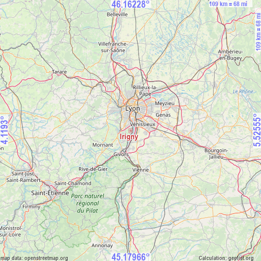
Irigny GPS coordinates[2]
45° 40' 23.268" North, 4° 49' 20.748" East
| Map corner | latitude | longitude |
|---|---|---|
| Upper-left | 46.16228°, | 4.1193° |
| Center: | 45.67313°, | 4.82243° |
| Lower-right: | 45.17966°, | 5.52555° |
| Map W x H: | 109.3×109.3 km | = 67.9×67.9mi |
| max Lat: | 51.07786° ⇑71.3% North |
| Irigny: | 45.67313° |
| min Lat: | ⇓28.7% South 41.3874° |
| min Long | Irigny | max Long |
| -5.08615° | 4.82243° | 9.52242° |
| W 75.4%⇐ | ⇒24.6% E |
Elevation
Elevation of Irigny is 178 m = 584 ft, and this is 15.7 m = 52 ft below average elevation for this country.
| Max E: |
2333 m = 7654 ft | 38.4% |
| Avg. | 193.7 m = 635 ft | |
| Irigny | 178 m = 584 ft | |
Min E: |
-1 m = -3 ft | 61.6% |
See also: France elevation on elevation.city.
Geographical zone
Irigny is located in North temperate zone (between Tropic of Cancer and the Arctic Circle). Distance of this North polar circle is 2322.8 km =1443.3 mi to North.| Distance of | km | miles | from Irigny |
|---|---|---|---|
| North Pole | 4928.7 | 3062.6 | to North |
| Arctic Circle | 2322.8 | 1443.3 | to North |
| Tropic Cancer | 2472.5 | 1536.3 | to South |
| Equator | 5078.4 | 3155.6 | to South |


Nearby cities:
15 places around Irigny: (largest is in red/bold)
• Brignais
5.3 km =3.3 mi,  270°
270°
• Charly
3.5 km =2.2 mi,  218°
218°
• Corbas
6.2 km =3.9 mi,  95°
95°
• Feyzin
2.8 km =1.7 mi,  90°
90°
• La Mulatière
6.2 km =3.9 mi,  352°
352°
• Millery
5.5 km =3.4 mi,  214°
214°
• Oullins
4.7 km =2.9 mi, 345°
• Pierre-Bénite
3.4 km =2.1 mi,  2°
2°
• Saint-Fons
4.6 km =2.9 mi,  31°
31°
• Saint-Genis-Laval
3.4 km =2.1 mi,  317°
317°
• Solaize
4 km =2.5 mi,  159°
159°
• Sérézin-du-Rhône
4.9 km =3 mi,  178°
178°
• Vernaison
2.9 km =1.8 mi,  196°
196°
• Vourles
4.1 km =2.5 mi,  247°
247°
• Vénissieux
5.6 km =3.5 mi,  61°
61°
Sources, notices
• [Note1] Compared only with cities in France existing in our database
• [Src1] Map data: © OpenStreetMap contributors (CC-BY-SA)
• [Src2] Other city data from geonames.org with taken over terms of usage.
• [Src3] Geographical zone / Annual Mean Temperature by Robert A. Rohde @ Wikipedia
