Annezin geodata
Annezin (Hauts-de-France) is a populated place; located in France in Europe/Paris (GMT+2) time zone. With population of 5,672 people, there are 1748 cities with bigger population in this country. Compared to other cities in France, 97.6% of cities are located further ↓South; 52.3% of cities are located further ←West and 92% of cities have higher elevation than Annezin. Note1
Administrative division(s):
- Level 1: Hauts-de-France
- Level 2: Pas-de-Calais
- Level 3: Arrondissement de Béthune
- Level 4: Annezin


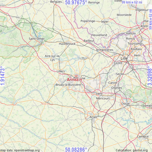
Annezin GPS coordinates[2]
50° 31' 54.912" North, 2° 37' 4.26" East
| Map corner | latitude | longitude |
|---|---|---|
| Upper-left | 50.97675°, | 1.91473° |
| Center: | 50.53192°, | 2.61785° |
| Lower-right: | 50.08286°, | 3.32098° |
| Map W x H: | 99.4×99.4 km | = 61.8×61.8mi |
| max Lat: | 51.07786° ⇑2.4% North |
| Annezin: | 50.53192° |
| min Lat: | ⇓97.6% South 41.3874° |
| min Long | Annezin | max Long |
| -5.08615° | 2.61785° | 9.52242° |
| W 52.3%⇐ | ⇒47.7% E |
Elevation
Elevation of Annezin is 25 m = 82 ft, and this is 168.7 m = 553 ft below average elevation for this country.
| Max E: |
2333 m = 7654 ft | 92% |
| Avg. | 193.7 m = 635 ft | |
| Annezin | 25 m = 82 ft | |
Min E: |
-1 m = -3 ft | 8% |
See also: France elevation on elevation.city.
Geographical zone
Annezin is located in North temperate zone (between Tropic of Cancer and the Arctic Circle). Distance of this North polar circle is 1782.6 km =1107.7 mi to North.| Distance of | km | miles | from Annezin |
|---|---|---|---|
| North Pole | 4388.4 | 2726.8 | to North |
| Arctic Circle | 1782.6 | 1107.7 | to North |
| Tropic Cancer | 3012.7 | 1872 | to South |
| Equator | 5618.6 | 3491.2 | to South |


Nearby cities:
15 places around Annezin: (largest is in red/bold)
• Beuvry
5.1 km =3.2 mi,  109°
109°
• Béthune
1.6 km =1 mi,  99°
99°
• Chocques
3.4 km =2.1 mi,  286°
286°
• Essars
3.9 km =2.4 mi,  61°
61°
• Fouquereuil
1.9 km =1.2 mi,  220°
220°
• Fouquières-lès-Béthune
1.9 km =1.2 mi,  196°
196°
• Gonnehem
4.5 km =2.8 mi,  315°
315°
• Gosnay
3.5 km =2.2 mi, 215°
• Hesdigneul-lès-Béthune
3.9 km =2.4 mi,  210°
210°
• Hinges
3.9 km =2.4 mi,  3°
3°
• Labeuvrière
4.2 km =2.6 mi,  249°
249°
• Locon
5.5 km =3.4 mi,  38°
38°
• Vaudricourt
3.5 km =2.2 mi,  171°
171°
• Vendin-lès-Béthune
1.5 km =0.9 mi,  306°
306°
• Verquin
3.6 km =2.2 mi,  155°
155°
Sources, notices
• [Note1] Compared only with cities in France existing in our database
• [Src1] Map data: © OpenStreetMap contributors (CC-BY-SA)
• [Src2] Other city data from geonames.org with taken over terms of usage.
• [Src3] Geographical zone / Annual Mean Temperature by Robert A. Rohde @ Wikipedia
