Art-sur-Meurthe geodata
Art-sur-Meurthe (Grand Est) is a populated place; located in France in Europe/Paris (GMT+2) time zone. With population of 1,660 people, there are 5636 cities with bigger population in this country. Compared to other cities in France, 72.2% of cities are located further ↓South; 89.9% of cities are located further ←West and 73.7% of cities have lower elevation than Art-sur-Meurthe. Note1
Administrative division(s):
- Level 1: Grand Est
- Level 2: Meurthe-et-Moselle
- Level 3: Arrondissement de Nancy
- Level 4: Art-sur-Meurthe


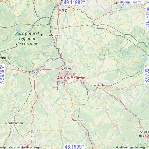
Art-sur-Meurthe GPS coordinates[2]
48° 39' 27" North, 6° 16' 1.488" East
| Map corner | latitude | longitude |
|---|---|---|
| Upper-left | 49.11982°, | 5.56395° |
| Center: | 48.6575°, | 6.26708° |
| Lower-right: | 48.1909°, | 6.9702° |
| Map W x H: | 103.3×103.3 km | = 64.2×64.2mi |
| max Lat: | 51.07786° ⇑27.8% North |
| Art-sur-Meurthe: | 48.6575° |
| min Lat: | ⇓72.2% South 41.3874° |
| min Long | Art-sur-Meurthe | max Long |
| -5.08615° | 6.26708° | 9.52242° |
| W 89.9%⇐ | ⇒10.1% E |
Elevation
Elevation of Art-sur-Meurthe is 240 m = 787 ft, and this is 46.3 m = 152 ft above average elevation for this country.
| Max E: |
2333 m = 7654 ft | 26.3% |
| Art-sur-Meurthe | 240 m 787 ft | |
| Avg. | 193.7 m = 635 ft | |
Min E: |
-1 m = -3 ft | 73.7% |
See also: France elevation on elevation.city.
Geographical zone
Art-sur-Meurthe is located in North temperate zone (between Tropic of Cancer and the Arctic Circle). Distance of this North polar circle is 1991 km =1237.1 mi to North.| Distance of | km | miles | from Art-sur-Meurthe |
|---|---|---|---|
| North Pole | 4596.9 | 2856.4 | to North |
| Arctic Circle | 1991 | 1237.1 | to North |
| Tropic Cancer | 2804.3 | 1742.5 | to South |
| Equator | 5410.2 | 3361.7 | to South |


Nearby cities:
15 places around Art-sur-Meurthe: (largest is in red/bold)
• Cerville
5.5 km =3.4 mi,  37°
37°
• Essey-lès-Nancy
6 km =3.7 mi,  330°
330°
• Fléville-devant-Nancy
5.9 km =3.7 mi,  232°
232°
• Heillecourt
5.3 km =3.3 mi,  261°
261°
• Jarville-la-Malgrange
4.8 km =3 mi,  282°
282°
• Laneuveville-devant-Nancy
3 km =1.9 mi,  268°
268°
• Nancy
6.7 km =4.2 mi,  296°
296°
• Pulnoy
5.2 km =3.2 mi,  352°
352°
• Saint-Nicolas-de-Port
3.9 km =2.4 mi,  145°
145°
• Saulxures-lès-Nancy
3.9 km =2.4 mi, 333°
• Seichamps
6.4 km =4 mi,  356°
356°
• Tomblaine
4.7 km =2.9 mi,  308°
308°
• Vandœuvre-lès-Nancy
6.2 km =3.9 mi, 262°
• Varangéville
4.4 km =2.7 mi,  121°
121°
• Ville-en-Vermois
4.9 km =3 mi,  191°
191°
Sources, notices
• [Note1] Compared only with cities in France existing in our database
• [Src1] Map data: © OpenStreetMap contributors (CC-BY-SA)
• [Src2] Other city data from geonames.org with taken over terms of usage.
• [Src3] Geographical zone / Annual Mean Temperature by Robert A. Rohde @ Wikipedia
