Saulxures-lès-Nancy geodata
Saulxures-lès-Nancy (Grand Est) is a populated place; located in France in Europe/Paris (GMT+2) time zone. With population of 3,981 people, there are 2472 cities with bigger population in this country. Compared to other cities in France, 72.9% of cities are located further ↓South; 89.7% of cities are located further ←West and 71% of cities have lower elevation than Saulxures-lès-Nancy. Note1
Administrative division(s):
- Level 1: Grand Est
- Level 2: Meurthe-et-Moselle
- Level 3: Arrondissement de Nancy
- Level 4: Saulxures-lès-Nancy


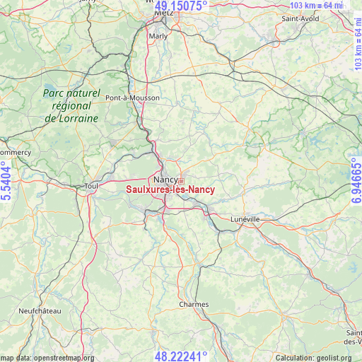
Saulxures-lès-Nancy GPS coordinates[2]
48° 41' 19.392" North, 6° 14' 36.708" East
| Map corner | latitude | longitude |
|---|---|---|
| Upper-left | 49.15075°, | 5.5404° |
| Center: | 48.68872°, | 6.24353° |
| Lower-right: | 48.22241°, | 6.94665° |
| Map W x H: | 103.2×103.2 km | = 64.1×64.1mi |
| max Lat: | 51.07786° ⇑27.1% North |
| Saulxures-lès-Nancy: | 48.68872° |
| min Lat: | ⇓72.9% South 41.3874° |
| min Long | Saulxures-lès- | max Long |
| -5.08615° | 6.24353° | 9.52242° |
| W 89.7%⇐ | ⇒10.3% E |
Elevation
Elevation of Saulxures-lès-Nancy is 224 m = 735 ft, and this is 30.3 m = 99 ft above average elevation for this country.
| Max E: |
2333 m = 7654 ft | 29% |
| Saulxures-lès-Nancy | 224 m 735 ft | |
| Avg. | 193.7 m = 635 ft | |
Min E: |
-1 m = -3 ft | 71% |
See also: France elevation on elevation.city.
Geographical zone
Saulxures-lès-Nancy is located in North temperate zone (between Tropic of Cancer and the Arctic Circle). Distance of this North polar circle is 1987.5 km =1235 mi to North.| Distance of | km | miles | from Saulxures-lès-Nancy |
|---|---|---|---|
| North Pole | 4593.4 | 2854.2 | to North |
| Arctic Circle | 1987.5 | 1235 | to North |
| Tropic Cancer | 2807.8 | 1744.7 | to South |
| Equator | 5413.7 | 3363.9 | to South |


Nearby cities:
15 places around Saulxures-lès-Nancy: (largest is in red/bold)
• Art-sur-Meurthe
3.9 km =2.4 mi,  153°
153°
• Cerville
5.1 km =3.2 mi,  80°
80°
• Dommartemont
3.5 km =2.2 mi,  322°
322°
• Essey-lès-Nancy
2.2 km =1.4 mi,  326°
326°
• Heillecourt
5.5 km =3.4 mi,  219°
219°
• Jarville-la-Malgrange
3.9 km =2.4 mi,  231°
231°
• Laneuveville-devant-Nancy
3.8 km =2.4 mi,  199°
199°
• Malzéville
5.1 km =3.2 mi,  301°
301°
• Maxéville
6.3 km =3.9 mi, 295°
• Nancy
4.3 km =2.7 mi,  263°
263°
• Pulnoy
1.9 km =1.2 mi,  32°
32°
• Saint-Max
3.2 km =2 mi, 302°
• Seichamps
3.2 km =2 mi,  24°
24°
• Tomblaine
2.1 km =1.3 mi,  254°
254°
• Vandœuvre-lès-Nancy
6.2 km =3.9 mi, 225°
Sources, notices
• [Note1] Compared only with cities in France existing in our database
• [Src1] Map data: © OpenStreetMap contributors (CC-BY-SA)
• [Src2] Other city data from geonames.org with taken over terms of usage.
• [Src3] Geographical zone / Annual Mean Temperature by Robert A. Rohde @ Wikipedia
