Tomblaine geodata
Tomblaine (Grand Est) is a populated place; located in France in Europe/Paris (GMT+2) time zone. With population of 7,703 people, there are 1254 cities with bigger population in this country. Compared to other cities in France, 72.9% of cities are located further ↓South; 89.4% of cities are located further ←West and 68.1% of cities have lower elevation than Tomblaine. Note1
Administrative division(s):
- Level 1: Grand Est
- Level 2: Meurthe-et-Moselle
- Level 3: Arrondissement de Nancy
- Level 4: Tomblaine


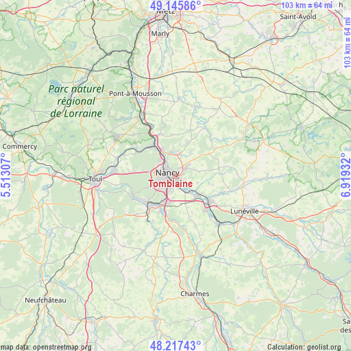
Tomblaine GPS coordinates[2]
48° 41' 1.608" North, 6° 12' 58.32" East
| Map corner | latitude | longitude |
|---|---|---|
| Upper-left | 49.14586°, | 5.51307° |
| Center: | 48.68378°, | 6.2162° |
| Lower-right: | 48.21743°, | 6.91932° |
| Map W x H: | 103.2×103.2 km | = 64.1×64.1mi |
| max Lat: | 51.07786° ⇑27.1% North |
| Tomblaine: | 48.68378° |
| min Lat: | ⇓72.9% South 41.3874° |
| min Long | Tomblaine | max Long |
| -5.08615° | 6.2162° | 9.52242° |
| W 89.4%⇐ | ⇒10.6% E |
Elevation
Elevation of Tomblaine is 210 m = 689 ft, and this is 16.3 m = 53 ft above average elevation for this country.
| Max E: |
2333 m = 7654 ft | 31.9% |
| Tomblaine | 210 m 689 ft | |
| Avg. | 193.7 m = 635 ft | |
Min E: |
-1 m = -3 ft | 68.1% |
See also: France elevation on elevation.city.
Geographical zone
Tomblaine is located in North temperate zone (between Tropic of Cancer and the Arctic Circle). Distance of this North polar circle is 1988 km =1235.3 mi to North.| Distance of | km | miles | from Tomblaine |
|---|---|---|---|
| North Pole | 4593.9 | 2854.5 | to North |
| Arctic Circle | 1988 | 1235.3 | to North |
| Tropic Cancer | 2807.2 | 1744.3 | to South |
| Equator | 5413.1 | 3363.5 | to South |


Nearby cities:
15 places around Tomblaine: (largest is in red/bold)
• Art-sur-Meurthe
4.7 km =2.9 mi,  128°
128°
• Dommartemont
3.3 km =2.1 mi,  358°
358°
• Essey-lès-Nancy
2.5 km =1.6 mi,  18°
18°
• Heillecourt
4 km =2.5 mi,  202°
202°
• Jarville-la-Malgrange
2.1 km =1.3 mi,  207°
207°
• Laneuveville-devant-Nancy
3.1 km =1.9 mi,  165°
165°
• Laxou
4.9 km =3 mi,  269°
269°
• Malzéville
3.9 km =2.4 mi,  323°
323°
• Nancy
2.3 km =1.4 mi, 271°
• Pulnoy
3.7 km =2.3 mi,  54°
54°
• Saint-Max
2.4 km =1.5 mi,  343°
343°
• Saulxures-lès-Nancy
2.1 km =1.3 mi,  74°
74°
• Seichamps
4.8 km =3 mi,  43°
43°
• Vandœuvre-lès-Nancy
4.5 km =2.8 mi, 212°
• Villers-lès-Nancy
4.8 km =3 mi,  255°
255°
Sources, notices
• [Note1] Compared only with cities in France existing in our database
• [Src1] Map data: © OpenStreetMap contributors (CC-BY-SA)
• [Src2] Other city data from geonames.org with taken over terms of usage.
• [Src3] Geographical zone / Annual Mean Temperature by Robert A. Rohde @ Wikipedia
