Valensole geodata
Valensole (Provence-Alpes-Côte d'Azur) is a populated place; located in France in Europe/Paris (GMT+2) time zone. With population of 2,479 people, there are 3919 cities with bigger population in this country. Compared to other cities in France, 88.7% of cities are located further ↑North; 86.9% of cities are located further ←West and 94.9% of cities have lower elevation than Valensole. Note1
Administrative division(s):
- Level 1: Provence-Alpes-Côte d'Azur
- Level 2: Alpes-de-Haute-Provence
- Level 3: Arrondissement de Forcalquier
- Level 4: Valensole


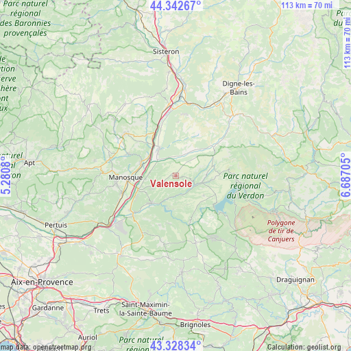
Valensole GPS coordinates[2]
43° 50' 15.576" North, 5° 59' 2.112" East
| Map corner | latitude | longitude |
|---|---|---|
| Upper-left | 44.34267°, | 5.2808° |
| Center: | 43.83766°, | 5.98392° |
| Lower-right: | 43.32834°, | 6.68705° |
| Map W x H: | 112.8×112.8 km | = 70.1×70.1mi |
| max Lat: | 51.07786° ⇑88.7% North |
| Valensole: | 43.83766° |
| min Lat: | ⇓11.3% South 41.3874° |
| min Long | Valensole | max Long |
| -5.08615° | 5.98392° | 9.52242° |
| W 86.9%⇐ | ⇒13.1% E |
Elevation
Elevation of Valensole is 582 m = 1909 ft, and this is 388.3 m = 1274 ft above average elevation for this country.
| Max E: |
2333 m = 7654 ft | 5.1% |
| Valensole | 582 m 1909 ft | |
| Avg. | 193.7 m = 635 ft | |
Min E: |
-1 m = -3 ft | 94.9% |
See also: France elevation on elevation.city.
Geographical zone
Valensole is located in North temperate zone (between Tropic of Cancer and the Arctic Circle). Distance of this Northern Tropic circle is 2268.4 km =1409.5 mi to South.| Distance of | km | miles | from Valensole |
|---|---|---|---|
| North Pole | 5132.8 | 3189.4 | to North |
| Arctic Circle | 2526.9 | 1570.1 | to North |
| Tropic Cancer | 2268.4 | 1409.5 | to South |
| Equator | 4874.3 | 3028.7 | to South |


Nearby cities:
15 places around Valensole: (largest is in red/bold)
• Bras-d’Asse
15 km =9.3 mi,  49°
49°
• Dauphin
17.5 km =10.9 mi,  292°
292°
• Gréoux-les-Bains
11.9 km =7.4 mi,  222°
222°
• La Brillanne
12.4 km =7.7 mi,  323°
323°
• Manosque
15.8 km =9.8 mi,  266°
266°
• Oraison
10.3 km =6.4 mi,  329°
329°
• Pierrerue
17.9 km =11.1 mi, 317°
• Puimoisson
11.8 km =7.3 mi,  76°
76°
• Riez
9 km =5.6 mi,  103°
103°
• Roumoules
11.8 km =7.3 mi, 96°
• Saint-Julien
17.4 km =10.8 mi,  200°
200°
• Saint-Maime
17 km =10.6 mi,  295°
295°
• Sainte-Tulle
18.5 km =11.5 mi,  251°
251°
• Villeneuve
11.6 km =7.2 mi, 302°
• Volx
12.3 km =7.6 mi, 291°
Sources, notices
• [Note1] Compared only with cities in France existing in our database
• [Src1] Map data: © OpenStreetMap contributors (CC-BY-SA)
• [Src2] Other city data from geonames.org with taken over terms of usage.
• [Src3] Geographical zone / Annual Mean Temperature by Robert A. Rohde @ Wikipedia
