Riez geodata
Riez (Provence-Alpes-Côte d'Azur) is a populated place; located in France in Europe/Paris (GMT+2) time zone. With population of 1,787 people, there are 5310 cities with bigger population in this country. Compared to other cities in France, 89% of cities are located further ↑North; 88.1% of cities are located further ←West and 94% of cities have lower elevation than Riez. Note1
Administrative division(s):
- Level 1: Provence-Alpes-Côte d'Azur
- Level 2: Alpes-de-Haute-Provence
- Level 3: Arrondissement de Forcalquier
- Level 4: Riez


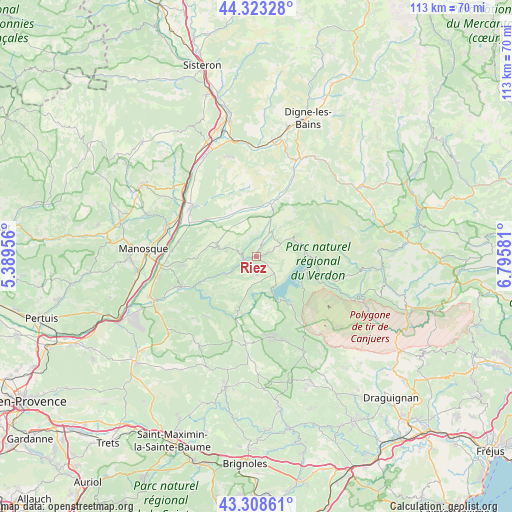
Riez GPS coordinates[2]
43° 49' 5.16" North, 6° 5' 33.648" East
| Map corner | latitude | longitude |
|---|---|---|
| Upper-left | 44.32328°, | 5.38956° |
| Center: | 43.8181°, | 6.09268° |
| Lower-right: | 43.30861°, | 6.79581° |
| Map W x H: | 112.8×112.8 km | = 70.1×70.1mi |
| max Lat: | 51.07786° ⇑89% North |
| Riez: | 43.8181° |
| min Lat: | ⇓11% South 41.3874° |
| min Long | Riez | max Long |
| -5.08615° | 6.09268° | 9.52242° |
| W 88.1%⇐ | ⇒11.9% E |
Elevation
Elevation of Riez is 541 m = 1775 ft, and this is 347.3 m = 1139 ft above average elevation for this country.
| Max E: |
2333 m = 7654 ft | 6% |
| Riez | 541 m 1775 ft | |
| Avg. | 193.7 m = 635 ft | |
Min E: |
-1 m = -3 ft | 94% |
See also: France elevation on elevation.city.
Geographical zone
Riez is located in North temperate zone (between Tropic of Cancer and the Arctic Circle). Distance of this Northern Tropic circle is 2266.2 km =1408.2 mi to South.| Distance of | km | miles | from Riez |
|---|---|---|---|
| North Pole | 5134.9 | 3190.7 | to North |
| Arctic Circle | 2529.1 | 1571.5 | to North |
| Tropic Cancer | 2266.2 | 1408.2 | to South |
| Equator | 4872.1 | 3027.4 | to South |


Nearby cities:
15 places around Riez: (largest is in red/bold)
• Aups
23.6 km =14.7 mi,  153°
153°
• Bras-d’Asse
12.2 km =7.6 mi,  12°
12°
• Gréoux-les-Bains
18.1 km =11.2 mi,  248°
248°
• La Brillanne
20.2 km =12.6 mi,  306°
306°
• La Verdière
23.7 km =14.7 mi,  212°
212°
• Moustiers-Sainte-Marie
10.8 km =6.7 mi,  73°
73°
• Mézel
21.5 km =13.4 mi,  22°
22°
• Oraison
17.8 km =11.1 mi, 308°
• Puimoisson
5.7 km =3.5 mi,  29°
29°
• Roumoules
3.1 km =1.9 mi, 74°
• Régusse
18.4 km =11.4 mi,  170°
170°
• Saint-Julien
20.5 km =12.7 mi,  226°
226°
• Valensole
9 km =5.6 mi,  283°
283°
• Villeneuve
20.3 km =12.6 mi,  294°
294°
• Volx
21.2 km =13.2 mi, 288°
Sources, notices
• [Note1] Compared only with cities in France existing in our database
• [Src1] Map data: © OpenStreetMap contributors (CC-BY-SA)
• [Src2] Other city data from geonames.org with taken over terms of usage.
• [Src3] Geographical zone / Annual Mean Temperature by Robert A. Rohde @ Wikipedia
