Saint-Georges-de-Pointindoux geodata
Saint-Georges-de-Pointindoux (Pays de la Loire) is a populated place; located in France in Europe/Paris (GMT+2) time zone. With population of 1,214 people, there are 7460 cities with bigger population in this country. Compared to other cities in France, 58.8% of cities are located further ↑North; 93.1% of cities are located further →East and 78.2% of cities have higher elevation than Saint-Georges-de-Pointindoux. Note1
Administrative division(s):
- Level 1: Pays de la Loire
- Level 2: Département de la Vendée
- Level 3: Arrondissement des Sables-d'Olonne
- Level 4: Saint-Georges-de-Pointindoux
Current local time in Saint-Georges-de-Pointindoux:
03:54 PM, SaturdayDifference from your time zone: hours


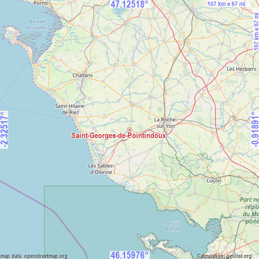
Saint-Georges-de-Pointindoux GPS coordinates[2]
46° 38' 40.632" North, 1° 37' 19.344" West
| Map corner | latitude | longitude |
|---|---|---|
| Upper-left | 47.12518°, | -2.32517° |
| Center: | 46.64462°, | -1.62204° |
| Lower-right: | 46.15976°, | -0.91891° |
| Map W x H: | 107.3×107.3 km | = 66.7×66.7mi |
| max Lat: | 51.07786° ⇑58.8% North |
| Saint-Georges-de-Pointindoux: | 46.64462° |
| min Lat: | ⇓41.2% South 41.3874° |
| min Long | Saint-Georges-d | max Long |
| -5.08615° | -1.62204° | 9.52242° |
| W 6.9%⇐ | ⇒93.1% E |
Elevation
Elevation of Saint-Georges-de-Pointindoux is 59 m = 194 ft, and this is 134.7 m = 442 ft below average elevation for this country.
| Max E: |
2333 m = 7654 ft | 78.2% |
| Avg. | 193.7 m = 635 ft | |
| Saint-Georges-de-Pointindoux | 59 m = 194 ft | |
Min E: |
-1 m = -3 ft | 21.8% |
See also: France elevation on elevation.city.
Geographical zone
Saint-Georges-de-Pointindoux is located in North temperate zone (between Tropic of Cancer and the Arctic Circle). Distance of this North polar circle is 2214.8 km =1376.2 mi to North.| Distance of | km | miles | from Saint-Georges-de-Pointindoux |
|---|---|---|---|
| North Pole | 4820.7 | 2995.4 | to North |
| Arctic Circle | 2214.8 | 1376.2 | to North |
| Tropic Cancer | 2580.5 | 1603.4 | to South |
| Equator | 5186.4 | 3222.7 | to South |


Nearby cities:
15 places around Saint-Georges-de-Pointindoux: (largest is in red/bold)
• Aizenay
10.7 km =6.6 mi,  5°
5°
• Beaulieu-sous-la-Roche
3.6 km =2.2 mi, 13°
• La Chapelle-Achard
6.5 km =4 mi,  197°
197°
• La Chapelle-Hermier
8.7 km =5.4 mi,  298°
298°
• La Mothe-Achard
4.3 km =2.7 mi,  221°
221°
• Landeronde
4.2 km =2.6 mi,  70°
70°
• Le Girouard
8.6 km =5.3 mi,  168°
168°
• Les Clouzeaux
8.8 km =5.5 mi,  101°
101°
• Martinet
5.7 km =3.5 mi,  307°
307°
• Nieul-le-Dolent
11.7 km =7.3 mi,  132°
132°
• Saint-Julien-des-Landes
7 km =4.3 mi,  265°
265°
• Saint-Mathurin
11.3 km =7 mi, 218°
• Sainte-Flaive-des-Loups
4.7 km =2.9 mi,  138°
138°
• Vairé
11.3 km =7 mi,  244°
244°
• Venansault
9.4 km =5.8 mi,  61°
61°
Sources, notices
• [Note1] Compared only with cities in France existing in our database
• [Src1] Map data: © OpenStreetMap contributors (CC-BY-SA)
• [Src2] Other city data from geonames.org with taken over terms of usage.
• [Src3] Geographical zone / Annual Mean Temperature by Robert A. Rohde @ Wikipedia
