Vaas geodata
Vaas (Pays de la Loire) is a populated place; located in France in Europe/Paris (GMT+2) time zone. With population of 1,725 people, there are 5461 cities with bigger population in this country. Compared to other cities in France, 53.7% of cities are located further ↓South; 75.2% of cities are located further →East and 83.1% of cities have higher elevation than Vaas. Note1
Administrative division(s):
- Level 1: Pays de la Loire
- Level 2: Sarthe
- Level 3: Arrondissement de La Flèche
- Level 4: Vaas


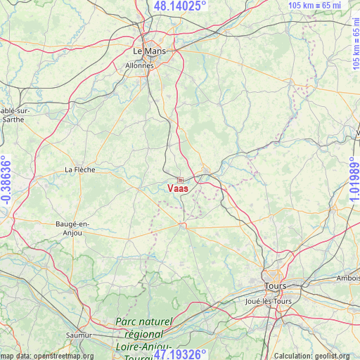
Vaas GPS coordinates[2]
47° 40' 8.04" North, 0° 19' 0.372" East
| Map corner | latitude | longitude |
|---|---|---|
| Upper-left | 48.14025°, | -0.38636° |
| Center: | 47.6689°, | 0.31677° |
| Lower-right: | 47.19326°, | 1.01989° |
| Map W x H: | 105.3×105.3 km | = 65.4×65.4mi |
| max Lat: | 51.07786° ⇑46.3% North |
| Vaas: | 47.6689° |
| min Lat: | ⇓53.7% South 41.3874° |
| min Long | Vaas | max Long |
| -5.08615° | 0.31677° | 9.52242° |
| W 24.8%⇐ | ⇒75.2% E |
Elevation
Elevation of Vaas is 47 m = 154 ft, and this is 146.7 m = 481 ft below average elevation for this country.
| Max E: |
2333 m = 7654 ft | 83.1% |
| Avg. | 193.7 m = 635 ft | |
| Vaas | 47 m = 154 ft | |
Min E: |
-1 m = -3 ft | 16.9% |
See also: France elevation on elevation.city.
Geographical zone
Vaas is located in North temperate zone (between Tropic of Cancer and the Arctic Circle). Distance of this North polar circle is 2100.9 km =1305.4 mi to North.| Distance of | km | miles | from Vaas |
|---|---|---|---|
| North Pole | 4706.8 | 2924.7 | to North |
| Arctic Circle | 2100.9 | 1305.4 | to North |
| Tropic Cancer | 2694.4 | 1674.2 | to South |
| Equator | 5300.3 | 3293.5 | to South |


Nearby cities:
15 places around Vaas: (largest is in red/bold)
• Aubigné-Racan
4.4 km =2.7 mi,  304°
304°
• Château-du-Loir
8.1 km =5 mi,  69°
69°
• Couesmes
11.8 km =7.3 mi,  170°
170°
• Coulongé
8.9 km =5.5 mi,  284°
284°
• Dissay-sous-Courcillon
11.7 km =7.3 mi,  92°
92°
• Flée
12.5 km =7.8 mi,  55°
55°
• Le Lude
12.2 km =7.6 mi,  258°
258°
• Luceau
7.7 km =4.8 mi,  51°
51°
• Mayet
10.6 km =6.6 mi,  342°
342°
• Montabon
5.3 km =3.3 mi, 72°
• Pontvallain
13.1 km =8.1 mi,  314°
314°
• Saint-Christophe-sur-le-Nais
13.4 km =8.3 mi,  115°
115°
• Verneil-le-Chétif
7.3 km =4.5 mi,  347°
347°
• Villiers-au-Bouin
10.5 km =6.5 mi,  181°
181°
• Vouvray-sur-Loir
11.4 km =7.1 mi, 74°
Sources, notices
• [Note1] Compared only with cities in France existing in our database
• [Src1] Map data: © OpenStreetMap contributors (CC-BY-SA)
• [Src2] Other city data from geonames.org with taken over terms of usage.
• [Src3] Geographical zone / Annual Mean Temperature by Robert A. Rohde @ Wikipedia
