Château-du-Loir geodata
Château-du-Loir (Pays de la Loire) is a populated place; located in France in Europe/Paris (GMT+2) time zone. With population of 5,567 people, there are 1779 cities with bigger population in this country. Compared to other cities in France, 54.1% of cities are located further ↓South; 74.1% of cities are located further →East and 78.2% of cities have higher elevation than Château-du-Loir. Note1
Administrative division(s):
- Level 1: Pays de la Loire
- Level 2: Sarthe
- Level 3: Arrondissement de La Flèche
- Level 4: Montval-sur-Loir


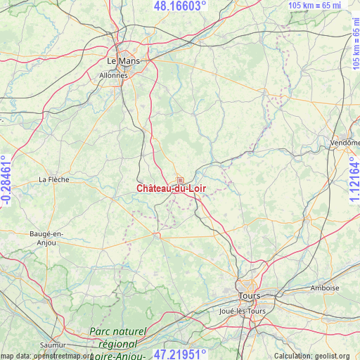
Château-du-Loir GPS coordinates[2]
47° 41' 41.712" North, 0° 25' 6.636" East
| Map corner | latitude | longitude |
|---|---|---|
| Upper-left | 48.16603°, | -0.28461° |
| Center: | 47.69492°, | 0.41851° |
| Lower-right: | 47.21951°, | 1.12164° |
| Map W x H: | 105.2×105.2 km | = 65.4×65.4mi |
| max Lat: | 51.07786° ⇑45.9% North |
| Château-du-Loir: | 47.69492° |
| min Lat: | ⇓54.1% South 41.3874° |
| min Long | Château-du-Loi | max Long |
| -5.08615° | 0.41851° | 9.52242° |
| W 25.9%⇐ | ⇒74.1% E |
Elevation
Elevation of Château-du-Loir is 59 m = 194 ft, and this is 134.7 m = 442 ft below average elevation for this country.
| Max E: |
2333 m = 7654 ft | 78.2% |
| Avg. | 193.7 m = 635 ft | |
| Château-du-Loir | 59 m = 194 ft | |
Min E: |
-1 m = -3 ft | 21.8% |
See also: France elevation on elevation.city.
Geographical zone
Château-du-Loir is located in North temperate zone (between Tropic of Cancer and the Arctic Circle). Distance of this North polar circle is 2098 km =1303.6 mi to North.| Distance of | km | miles | from Château-du-Loir |
|---|---|---|---|
| North Pole | 4703.9 | 2922.9 | to North |
| Arctic Circle | 2098 | 1303.6 | to North |
| Tropic Cancer | 2697.3 | 1676 | to South |
| Equator | 5303.2 | 3295.3 | to South |


Nearby cities:
15 places around Château-du-Loir: (largest is in red/bold)
• Aubigné-Racan
11.2 km =7 mi,  267°
267°
• Chahaignes
8.8 km =5.5 mi,  53°
53°
• Dissay-sous-Courcillon
5.3 km =3.3 mi,  129°
129°
• Flée
5 km =3.1 mi,  31°
31°
• Jupilles
10.7 km =6.6 mi,  357°
357°
• La Chartre-sur-le-Loir
11.9 km =7.4 mi,  70°
70°
• Lhomme
11.8 km =7.3 mi,  62°
62°
• Luceau
2.4 km =1.5 mi,  319°
319°
• Marçon
7.1 km =4.4 mi,  75°
75°
• Montabon
2.9 km =1.8 mi,  242°
242°
• Saint-Christophe-sur-le-Nais
9.7 km =6 mi,  152°
152°
• Saint-Paterne-Racan
11.4 km =7.1 mi, 154°
• Vaas
8.1 km =5 mi,  249°
249°
• Verneil-le-Chétif
10.1 km =6.3 mi,  294°
294°
• Vouvray-sur-Loir
3.4 km =2.1 mi,  89°
89°
Sources, notices
• [Note1] Compared only with cities in France existing in our database
• [Src1] Map data: © OpenStreetMap contributors (CC-BY-SA)
• [Src2] Other city data from geonames.org with taken over terms of usage.
• [Src3] Geographical zone / Annual Mean Temperature by Robert A. Rohde @ Wikipedia
