Le Lude geodata
Le Lude (Pays de la Loire) is a populated place; located in France in Europe/Paris (GMT+2) time zone. With population of 4,465 people, there are 2211 cities with bigger population in this country. Compared to other cities in France, 53.4% of cities are located further ↓South; 76.6% of cities are located further →East and 81.5% of cities have higher elevation than Le Lude. Note1
Administrative division(s):
- Level 1: Pays de la Loire
- Level 2: Sarthe
- Level 3: Arrondissement de La Flèche
- Level 4: Le Lude


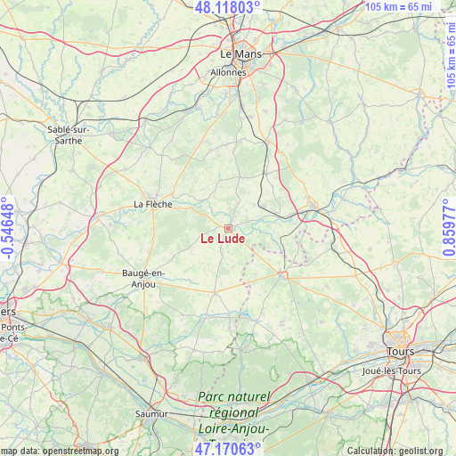
Le Lude GPS coordinates[2]
47° 38' 47.328" North, 0° 9' 23.904" East
| Map corner | latitude | longitude |
|---|---|---|
| Upper-left | 48.11803°, | -0.54648° |
| Center: | 47.64648°, | 0.15664° |
| Lower-right: | 47.17063°, | 0.85977° |
| Map W x H: | 105.3×105.3 km | = 65.4×65.4mi |
| max Lat: | 51.07786° ⇑46.6% North |
| Le Lude: | 47.64648° |
| min Lat: | ⇓53.4% South 41.3874° |
| min Long | Le Lude | max Long |
| -5.08615° | 0.15664° | 9.52242° |
| W 23.4%⇐ | ⇒76.6% E |
Elevation
Elevation of Le Lude is 51 m = 167 ft, and this is 142.7 m = 468 ft below average elevation for this country.
| Max E: |
2333 m = 7654 ft | 81.5% |
| Avg. | 193.7 m = 635 ft | |
| Le Lude | 51 m = 167 ft | |
Min E: |
-1 m = -3 ft | 18.5% |
See also: France elevation on elevation.city.
Geographical zone
Le Lude is located in North temperate zone (between Tropic of Cancer and the Arctic Circle). Distance of this North polar circle is 2103.4 km =1307 mi to North.| Distance of | km | miles | from Le Lude |
|---|---|---|---|
| North Pole | 4709.3 | 2926.2 | to North |
| Arctic Circle | 2103.4 | 1307 | to North |
| Tropic Cancer | 2691.9 | 1672.7 | to South |
| Equator | 5297.8 | 3291.9 | to South |


Nearby cities:
15 places around Le Lude: (largest is in red/bold)
• Aubigné-Racan
9.7 km =6 mi,  59°
59°
• Clermont-Créans
15.1 km =9.4 mi,  301°
301°
• Coulongé
5.8 km =3.6 mi,  35°
35°
• Dissé-sous-le-Lude
4.1 km =2.5 mi,  182°
182°
• Luché-Pringé
8.8 km =5.5 mi,  316°
316°
• Mansigné
11.5 km =7.1 mi,  351°
351°
• Mareil-sur-Loir
13.3 km =8.3 mi, 304°
• Mayet
15.4 km =9.6 mi, 35°
• Pontvallain
12 km =7.5 mi,  12°
12°
• Requeil
15.3 km =9.5 mi,  1°
1°
• Saint-Jean-de-la-Motte
13.1 km =8.1 mi,  325°
325°
• Thorée-les-Pins
9.7 km =6 mi, 297°
• Vaas
12.2 km =7.6 mi,  78°
78°
• Verneil-le-Chétif
14.2 km =8.8 mi,  47°
47°
• Villiers-au-Bouin
14.2 km =8.8 mi,  124°
124°
Sources, notices
• [Note1] Compared only with cities in France existing in our database
• [Src1] Map data: © OpenStreetMap contributors (CC-BY-SA)
• [Src2] Other city data from geonames.org with taken over terms of usage.
• [Src3] Geographical zone / Annual Mean Temperature by Robert A. Rohde @ Wikipedia
