Trévol geodata
Trévol (Auvergne-Rhône-Alpes) is a populated place; located in France in Europe/Paris (GMT+2) time zone. With population of 1,435 people, there are 6457 cities with bigger population in this country. Compared to other cities in France, 59% of cities are located further ↑North; 62.1% of cities are located further ←West and 72% of cities have lower elevation than Trévol. Note1
Administrative division(s):
- Level 1: Auvergne-Rhône-Alpes
- Level 2: Département de l'Allier
- Level 3: Arrondissement de Moulins
- Level 4: Trévol


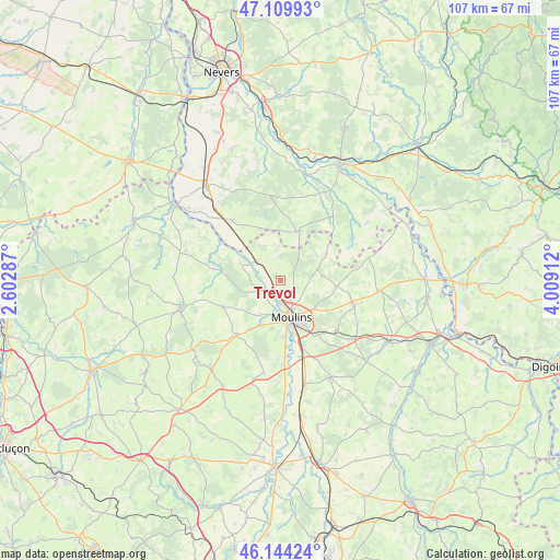
Trévol GPS coordinates[2]
46° 37' 45.264" North, 3° 18' 21.564" East
| Map corner | latitude | longitude |
|---|---|---|
| Upper-left | 47.10993°, | 2.60287° |
| Center: | 46.62924°, | 3.30599° |
| Lower-right: | 46.14424°, | 4.00912° |
| Map W x H: | 107.4×107.4 km | = 66.7×66.7mi |
| max Lat: | 51.07786° ⇑59% North |
| Trévol: | 46.62924° |
| min Lat: | ⇓41% South 41.3874° |
| min Long | Trévol | max Long |
| -5.08615° | 3.30599° | 9.52242° |
| W 62.1%⇐ | ⇒37.9% E |
Elevation
Elevation of Trévol is 230 m = 755 ft, and this is 36.3 m = 119 ft above average elevation for this country.
| Max E: |
2333 m = 7654 ft | 28% |
| Trévol | 230 m 755 ft | |
| Avg. | 193.7 m = 635 ft | |
Min E: |
-1 m = -3 ft | 72% |
See also: France elevation on elevation.city.
Geographical zone
Trévol is located in North temperate zone (between Tropic of Cancer and the Arctic Circle). Distance of this North polar circle is 2216.5 km =1377.3 mi to North.| Distance of | km | miles | from Trévol |
|---|---|---|---|
| North Pole | 4822.4 | 2996.5 | to North |
| Arctic Circle | 2216.5 | 1377.3 | to North |
| Tropic Cancer | 2578.8 | 1602.4 | to South |
| Equator | 5184.7 | 3221.6 | to South |


Nearby cities:
15 places around Trévol: (largest is in red/bold)
• Avermes
4.6 km =2.9 mi,  178°
178°
• Bressolles
11 km =6.8 mi, 175°
• Chantenay-Saint-Imbert
14.9 km =9.3 mi,  321°
321°
• Coulandon
9.5 km =5.9 mi,  203°
203°
• Dornes
10.3 km =6.4 mi,  20°
20°
• Lusigny
14.9 km =9.3 mi,  108°
108°
• Montilly
4.5 km =2.8 mi,  245°
245°
• Moulins
7.5 km =4.7 mi,  164°
164°
• Neuvy
7.6 km =4.7 mi,  189°
189°
• Saint-Ennemond
10.3 km =6.4 mi,  59°
59°
• Saint-Menoux
12.2 km =7.6 mi, 245°
• Souvigny
13.6 km =8.5 mi,  219°
219°
• Toulon-sur-Allier
13 km =8.1 mi, 161°
• Villeneuve-sur-Allier
5.6 km =3.5 mi,  308°
308°
• Yzeure
8 km =5 mi,  152°
152°
Sources, notices
• [Note1] Compared only with cities in France existing in our database
• [Src1] Map data: © OpenStreetMap contributors (CC-BY-SA)
• [Src2] Other city data from geonames.org with taken over terms of usage.
• [Src3] Geographical zone / Annual Mean Temperature by Robert A. Rohde @ Wikipedia
