Toulon-sur-Allier geodata
Toulon-sur-Allier (Auvergne-Rhône-Alpes) is a populated place; located in France in Europe/Paris (GMT+2) time zone. With population of 1,106 people, there are 8091 cities with bigger population in this country. Compared to other cities in France, 60% of cities are located further ↑North; 62.8% of cities are located further ←West and 72.5% of cities have lower elevation than Toulon-sur-Allier. Note1
Administrative division(s):
- Level 1: Auvergne-Rhône-Alpes
- Level 2: Département de l'Allier
- Level 3: Arrondissement de Moulins
- Level 4: Toulon-sur-Allier


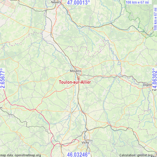
Toulon-sur-Allier GPS coordinates[2]
46° 31' 6.42" North, 3° 21' 35.604" East
| Map corner | latitude | longitude |
|---|---|---|
| Upper-left | 47.00013°, | 2.65677° |
| Center: | 46.51845°, | 3.35989° |
| Lower-right: | 46.03246°, | 4.06302° |
| Map W x H: | 107.6×107.6 km | = 66.9×66.9mi |
| max Lat: | 51.07786° ⇑60% North |
| Toulon-sur-Allier: | 46.51845° |
| min Lat: | ⇓40% South 41.3874° |
| min Long | Toulon-sur-Alli | max Long |
| -5.08615° | 3.35989° | 9.52242° |
| W 62.8%⇐ | ⇒37.2% E |
Elevation
Elevation of Toulon-sur-Allier is 233 m = 764 ft, and this is 39.3 m = 129 ft above average elevation for this country.
| Max E: |
2333 m = 7654 ft | 27.5% |
| Toulon-sur-Allier | 233 m 764 ft | |
| Avg. | 193.7 m = 635 ft | |
Min E: |
-1 m = -3 ft | 72.5% |
See also: France elevation on elevation.city.
Geographical zone
Toulon-sur-Allier is located in North temperate zone (between Tropic of Cancer and the Arctic Circle). Distance of this North polar circle is 2228.8 km =1384.9 mi to North.| Distance of | km | miles | from Toulon-sur-Allier |
|---|---|---|---|
| North Pole | 4834.7 | 3004.1 | to North |
| Arctic Circle | 2228.8 | 1384.9 | to North |
| Tropic Cancer | 2566.4 | 1594.7 | to South |
| Equator | 5172.4 | 3214 | to South |


Nearby cities:
15 places around Toulon-sur-Allier: (largest is in red/bold)
• Avermes
8.7 km =5.4 mi,  332°
332°
• Bessay-sur-Allier
8.5 km =5.3 mi,  178°
178°
• Besson
9.1 km =5.7 mi,  233°
233°
• Bressolles
3.6 km =2.2 mi,  292°
292°
• Chemilly
4.8 km =3 mi, 225°
• Châtel-de-Neuvre
13 km =8.1 mi,  196°
196°
• Coulandon
8.7 km =5.4 mi, 294°
• Lusigny
12.7 km =7.9 mi,  52°
52°
• Montbeugny
9.9 km =6.2 mi,  83°
83°
• Moulins
5.5 km =3.4 mi,  337°
337°
• Neuilly-le-Réal
8.2 km =5.1 mi,  137°
137°
• Neuvy
7.2 km =4.5 mi,  312°
312°
• Souvigny
13 km =8.1 mi,  278°
278°
• Trévol
13 km =8.1 mi, 341°
• Yzeure
5.3 km =3.3 mi,  355°
355°
Sources, notices
• [Note1] Compared only with cities in France existing in our database
• [Src1] Map data: © OpenStreetMap contributors (CC-BY-SA)
• [Src2] Other city data from geonames.org with taken over terms of usage.
• [Src3] Geographical zone / Annual Mean Temperature by Robert A. Rohde @ Wikipedia
