Yzeure geodata
Yzeure (Auvergne-Rhône-Alpes) is a populated place; located in France in Europe/Paris (GMT+2) time zone. With population of 13,435 people, there are 711 cities with bigger population in this country. Compared to other cities in France, 59.6% of cities are located further ↑North; 62.7% of cities are located further ←West and 74.3% of cities have lower elevation than Yzeure. Note1
Administrative division(s):
- Level 1: Auvergne-Rhône-Alpes
- Level 2: Département de l'Allier
- Level 3: Arrondissement de Moulins
- Level 4: Yzeure


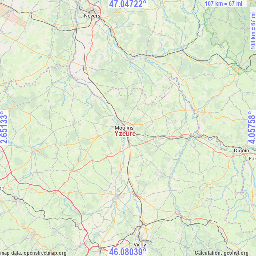
Yzeure GPS coordinates[2]
46° 33' 57.456" North, 3° 21' 16.056" East
| Map corner | latitude | longitude |
|---|---|---|
| Upper-left | 47.04722°, | 2.65133° |
| Center: | 46.56596°, | 3.35446° |
| Lower-right: | 46.08039°, | 4.05758° |
| Map W x H: | 107.5×107.5 km | = 66.8×66.8mi |
| max Lat: | 51.07786° ⇑59.6% North |
| Yzeure: | 46.56596° |
| min Lat: | ⇓40.4% South 41.3874° |
| min Long | Yzeure | max Long |
| -5.08615° | 3.35446° | 9.52242° |
| W 62.7%⇐ | ⇒37.3% E |
Elevation
Elevation of Yzeure is 244 m = 801 ft, and this is 50.3 m = 165 ft above average elevation for this country.
| Max E: |
2333 m = 7654 ft | 25.7% |
| Yzeure | 244 m 801 ft | |
| Avg. | 193.7 m = 635 ft | |
Min E: |
-1 m = -3 ft | 74.3% |
See also: France elevation on elevation.city.
Geographical zone
Yzeure is located in North temperate zone (between Tropic of Cancer and the Arctic Circle). Distance of this North polar circle is 2223.5 km =1381.6 mi to North.| Distance of | km | miles | from Yzeure |
|---|---|---|---|
| North Pole | 4829.4 | 3000.8 | to North |
| Arctic Circle | 2223.5 | 1381.6 | to North |
| Tropic Cancer | 2571.7 | 1598 | to South |
| Equator | 5177.6 | 3217.2 | to South |


Nearby cities:
15 places around Yzeure: (largest is in red/bold)
• Avermes
4.3 km =2.7 mi,  303°
303°
• Besson
12.7 km =7.9 mi,  212°
212°
• Bressolles
4.9 km =3 mi,  216°
216°
• Chemilly
9.2 km =5.7 mi,  199°
199°
• Coulandon
7.7 km =4.8 mi,  257°
257°
• Lusigny
10.7 km =6.6 mi,  76°
76°
• Montbeugny
11.1 km =6.9 mi,  111°
111°
• Montilly
9.4 km =5.8 mi, 303°
• Moulins
1.7 km =1.1 mi, 264°
• Neuilly-le-Réal
12.8 km =8 mi,  152°
152°
• Neuvy
4.9 km =3 mi, 264°
• Souvigny
12.9 km =8 mi,  254°
254°
• Toulon-sur-Allier
5.3 km =3.3 mi,  175°
175°
• Trévol
8 km =5 mi,  332°
332°
• Villeneuve-sur-Allier
13.2 km =8.2 mi,  322°
322°
Sources, notices
• [Note1] Compared only with cities in France existing in our database
• [Src1] Map data: © OpenStreetMap contributors (CC-BY-SA)
• [Src2] Other city data from geonames.org with taken over terms of usage.
• [Src3] Geographical zone / Annual Mean Temperature by Robert A. Rohde @ Wikipedia
