Saint-Menoux geodata
Saint-Menoux (Auvergne-Rhône-Alpes) is a populated place; located in France in Europe/Paris (GMT+2) time zone. With population of 922 people, there are 9460 cities with bigger population in this country. Compared to other cities in France, 59.4% of cities are located further ↑North; 60.1% of cities are located further ←West and 74.6% of cities have lower elevation than Saint-Menoux. Note1
Administrative division(s):
- Level 1: Auvergne-Rhône-Alpes
- Level 2: Département de l'Allier
- Level 3: Arrondissement de Moulins
- Level 4: Saint-Menoux


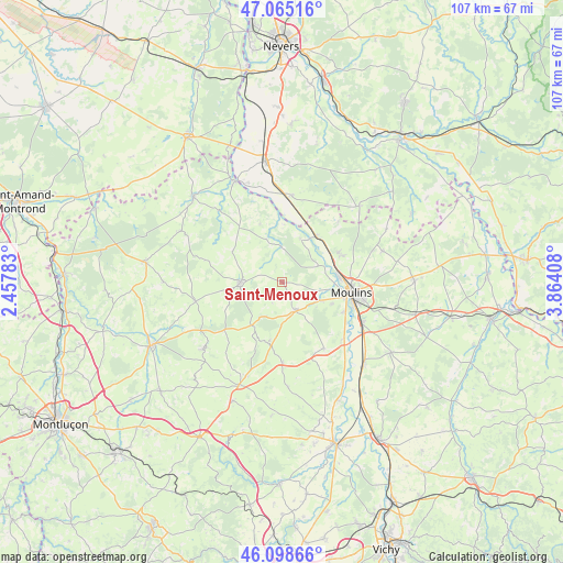
Saint-Menoux GPS coordinates[2]
46° 35' 2.616" North, 3° 9' 39.456" East
| Map corner | latitude | longitude |
|---|---|---|
| Upper-left | 47.06516°, | 2.45783° |
| Center: | 46.58406°, | 3.16096° |
| Lower-right: | 46.09866°, | 3.86408° |
| Map W x H: | 107.5×107.5 km | = 66.8×66.8mi |
| max Lat: | 51.07786° ⇑59.4% North |
| Saint-Menoux: | 46.58406° |
| min Lat: | ⇓40.6% South 41.3874° |
| min Long | Saint-Menoux | max Long |
| -5.08615° | 3.16096° | 9.52242° |
| W 60.1%⇐ | ⇒39.9% E |
Elevation
Elevation of Saint-Menoux is 246 m = 807 ft, and this is 52.3 m = 172 ft above average elevation for this country.
| Max E: |
2333 m = 7654 ft | 25.4% |
| Saint-Menoux | 246 m 807 ft | |
| Avg. | 193.7 m = 635 ft | |
Min E: |
-1 m = -3 ft | 74.6% |
See also: France elevation on elevation.city.
Geographical zone
Saint-Menoux is located in North temperate zone (between Tropic of Cancer and the Arctic Circle). Distance of this North polar circle is 2221.5 km =1380.4 mi to North.| Distance of | km | miles | from Saint-Menoux |
|---|---|---|---|
| North Pole | 4827.4 | 2999.6 | to North |
| Arctic Circle | 2221.5 | 1380.4 | to North |
| Tropic Cancer | 2573.7 | 1599.2 | to South |
| Equator | 5179.7 | 3218.5 | to South |


Nearby cities:
15 places around Saint-Menoux: (largest is in red/bold)
• Avermes
11.2 km =7 mi,  87°
87°
• Besson
14.9 km =9.3 mi,  148°
148°
• Bourbon-l’Archambault
8 km =5 mi,  269°
269°
• Bressolles
13.3 km =8.3 mi,  116°
116°
• Coulandon
8.2 km =5.1 mi, 117°
• Cressanges
15.4 km =9.6 mi,  180°
180°
• Montilly
7.6 km =4.7 mi,  65°
65°
• Moulins
13.3 km =8.3 mi,  99°
99°
• Neuvy
10.2 km =6.3 mi, 103°
• Noyant-d’Allier
12 km =7.5 mi,  193°
193°
• Saint-Hilaire
14.7 km =9.1 mi,  227°
227°
• Souvigny
6 km =3.7 mi,  156°
156°
• Trévol
12.2 km =7.6 mi, 65°
• Villeneuve-sur-Allier
10.8 km =6.7 mi,  38°
38°
• Yzeure
14.9 km =9.3 mi, 97°
Sources, notices
• [Note1] Compared only with cities in France existing in our database
• [Src1] Map data: © OpenStreetMap contributors (CC-BY-SA)
• [Src2] Other city data from geonames.org with taken over terms of usage.
• [Src3] Geographical zone / Annual Mean Temperature by Robert A. Rohde @ Wikipedia
