Souvigny geodata
Souvigny (Auvergne-Rhône-Alpes) is a populated place; located in France in Europe/Paris (GMT+2) time zone. With population of 1,987 people, there are 4818 cities with bigger population in this country. Compared to other cities in France, 59.8% of cities are located further ↑North; 60.5% of cities are located further ←West and 73.5% of cities have lower elevation than Souvigny. Note1
Administrative division(s):
- Level 1: Auvergne-Rhône-Alpes
- Level 2: Département de l'Allier
- Level 3: Arrondissement de Moulins
- Level 4: Souvigny


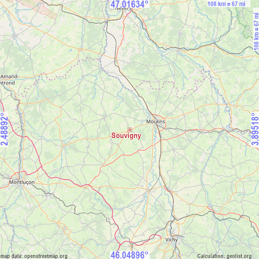
Souvigny GPS coordinates[2]
46° 32' 5.28" North, 3° 11' 31.38" East
| Map corner | latitude | longitude |
|---|---|---|
| Upper-left | 47.01634°, | 2.48892° |
| Center: | 46.5348°, | 3.19205° |
| Lower-right: | 46.04896°, | 3.89518° |
| Map W x H: | 107.6×107.6 km | = 66.9×66.9mi |
| max Lat: | 51.07786° ⇑59.8% North |
| Souvigny: | 46.5348° |
| min Lat: | ⇓40.2% South 41.3874° |
| min Long | Souvigny | max Long |
| -5.08615° | 3.19205° | 9.52242° |
| W 60.5%⇐ | ⇒39.5% E |
Elevation
Elevation of Souvigny is 239 m = 784 ft, and this is 45.3 m = 149 ft above average elevation for this country.
| Max E: |
2333 m = 7654 ft | 26.5% |
| Souvigny | 239 m 784 ft | |
| Avg. | 193.7 m = 635 ft | |
Min E: |
-1 m = -3 ft | 73.5% |
See also: France elevation on elevation.city.
Geographical zone
Souvigny is located in North temperate zone (between Tropic of Cancer and the Arctic Circle). Distance of this North polar circle is 2227 km =1383.8 mi to North.| Distance of | km | miles | from Souvigny |
|---|---|---|---|
| North Pole | 4832.9 | 3003 | to North |
| Arctic Circle | 2227 | 1383.8 | to North |
| Tropic Cancer | 2568.3 | 1595.9 | to South |
| Equator | 5174.2 | 3215.1 | to South |


Nearby cities:
15 places around Souvigny: (largest is in red/bold)
• Avermes
10.6 km =6.6 mi,  56°
56°
• Besson
9.1 km =5.7 mi,  142°
142°
• Bourbon-l’Archambault
11.7 km =7.3 mi,  297°
297°
• Bressolles
9.5 km =5.9 mi,  92°
92°
• Chemilly
10.7 km =6.6 mi,  119°
119°
• Coulandon
5.2 km =3.2 mi,  70°
70°
• Cressanges
10.2 km =6.3 mi,  193°
193°
• Montilly
9.8 km =6.1 mi,  27°
27°
• Moulins
11.2 km =7 mi, 72°
• Neuvy
8.1 km =5 mi, 68°
• Noyant-d’Allier
8.1 km =5 mi,  220°
220°
• Saint-Menoux
6 km =3.7 mi,  336°
336°
• Toulon-sur-Allier
13 km =8.1 mi,  98°
98°
• Trévol
13.6 km =8.5 mi,  39°
39°
• Yzeure
12.9 km =8 mi, 74°
Sources, notices
• [Note1] Compared only with cities in France existing in our database
• [Src1] Map data: © OpenStreetMap contributors (CC-BY-SA)
• [Src2] Other city data from geonames.org with taken over terms of usage.
• [Src3] Geographical zone / Annual Mean Temperature by Robert A. Rohde @ Wikipedia
