Montilly geodata
Montilly (Auvergne-Rhône-Alpes) is a populated place; located in France in Europe/Paris (GMT+2) time zone. With population of 529 people, there are 14624 cities with bigger population in this country. Compared to other cities in France, 59.1% of cities are located further ↑North; 61.3% of cities are located further ←West and 72.8% of cities have lower elevation than Montilly. Note1
Administrative division(s):
- Level 1: Auvergne-Rhône-Alpes
- Level 2: Département de l'Allier
- Level 3: Arrondissement de Moulins
- Level 4: Montilly


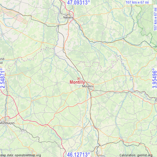
Montilly GPS coordinates[2]
46° 36' 44.208" North, 3° 15' 6.588" East
| Map corner | latitude | longitude |
|---|---|---|
| Upper-left | 47.09313°, | 2.54871° |
| Center: | 46.61228°, | 3.25183° |
| Lower-right: | 46.12713°, | 3.95496° |
| Map W x H: | 107.4×107.4 km | = 66.7×66.7mi |
| max Lat: | 51.07786° ⇑59.1% North |
| Montilly: | 46.61228° |
| min Lat: | ⇓40.9% South 41.3874° |
| min Long | Montilly | max Long |
| -5.08615° | 3.25183° | 9.52242° |
| W 61.3%⇐ | ⇒38.7% E |
Elevation
Elevation of Montilly is 235 m = 771 ft, and this is 41.3 m = 135 ft above average elevation for this country.
| Max E: |
2333 m = 7654 ft | 27.2% |
| Montilly | 235 m 771 ft | |
| Avg. | 193.7 m = 635 ft | |
Min E: |
-1 m = -3 ft | 72.8% |
See also: France elevation on elevation.city.
Geographical zone
Montilly is located in North temperate zone (between Tropic of Cancer and the Arctic Circle). Distance of this North polar circle is 2218.4 km =1378.4 mi to North.| Distance of | km | miles | from Montilly |
|---|---|---|---|
| North Pole | 4824.3 | 2997.7 | to North |
| Arctic Circle | 2218.4 | 1378.4 | to North |
| Tropic Cancer | 2576.9 | 1601.2 | to South |
| Equator | 5182.8 | 3220.4 | to South |


Nearby cities:
15 places around Montilly: (largest is in red/bold)
• Avermes
5 km =3.1 mi,  122°
122°
• Bressolles
10.3 km =6.4 mi,  151°
151°
• Chantenay-Saint-Imbert
14.4 km =8.9 mi,  338°
338°
• Chemilly
14.6 km =9.1 mi,  160°
160°
• Coulandon
6.9 km =4.3 mi,  177°
177°
• Dornes
13.9 km =8.6 mi,  33°
33°
• Moulins
8.1 km =5 mi,  130°
130°
• Neuvy
6.3 km =3.9 mi, 152°
• Saint-Ennemond
14.8 km =9.2 mi,  61°
61°
• Saint-Menoux
7.6 km =4.7 mi,  245°
245°
• Souvigny
9.8 km =6.1 mi,  207°
207°
• Toulon-sur-Allier
13.3 km =8.3 mi,  141°
141°
• Trévol
4.5 km =2.8 mi,  65°
65°
• Villeneuve-sur-Allier
5.3 km =3.3 mi,  357°
357°
• Yzeure
9.4 km =5.8 mi, 123°
Sources, notices
• [Note1] Compared only with cities in France existing in our database
• [Src1] Map data: © OpenStreetMap contributors (CC-BY-SA)
• [Src2] Other city data from geonames.org with taken over terms of usage.
• [Src3] Geographical zone / Annual Mean Temperature by Robert A. Rohde @ Wikipedia
