Tréguidel geodata
Tréguidel (Brittany) is a populated place; located in France in Europe/Paris (GMT+2) time zone. With population of 558 people, there are 14045 cities with bigger population in this country. Compared to other cities in France, 70.9% of cities are located further ↓South; 97.2% of cities are located further →East and 60% of cities have higher elevation than Tréguidel. Note1
Administrative division(s):
- Level 1: Brittany
- Level 2: Département des Côtes-d’Armor
- Level 3: Arrondissement de Guingamp
- Level 4: Tréguidel


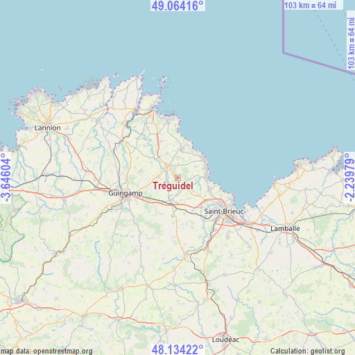
Tréguidel GPS coordinates[2]
48° 36' 4.788" North, 2° 56' 34.476" West
| Map corner | latitude | longitude |
|---|---|---|
| Upper-left | 49.06416°, | -3.64604° |
| Center: | 48.60133°, | -2.94291° |
| Lower-right: | 48.13422°, | -2.23979° |
| Map W x H: | 103.4×103.4 km | = 64.2×64.2mi |
| max Lat: | 51.07786° ⇑29.1% North |
| Tréguidel: | 48.60133° |
| min Lat: | ⇓70.9% South 41.3874° |
| min Long | Tréguidel | max Long |
| -5.08615° | -2.94291° | 9.52242° |
| W 2.8%⇐ | ⇒97.2% E |
Elevation
Elevation of Tréguidel is 102 m = 335 ft, and this is 91.7 m = 301 ft below average elevation for this country.
| Max E: |
2333 m = 7654 ft | 60% |
| Avg. | 193.7 m = 635 ft | |
| Tréguidel | 102 m = 335 ft | |
Min E: |
-1 m = -3 ft | 40% |
See also: France elevation on elevation.city.
Geographical zone
Tréguidel is located in North temperate zone (between Tropic of Cancer and the Arctic Circle). Distance of this North polar circle is 1997.2 km =1241 mi to North.| Distance of | km | miles | from Tréguidel |
|---|---|---|---|
| North Pole | 4603.1 | 2860.2 | to North |
| Arctic Circle | 1997.2 | 1241 | to North |
| Tropic Cancer | 2798 | 1738.6 | to South |
| Equator | 5404 | 3357.9 | to South |


Nearby cities:
15 places around Tréguidel: (largest is in red/bold)
• Binic
8.6 km =5.3 mi,  90°
90°
• Châtelaudren
7.1 km =4.4 mi,  197°
197°
• Goudelin
5.6 km =3.5 mi,  272°
272°
• Lantic
4.5 km =2.8 mi,  82°
82°
• Lanvollon
4.6 km =2.9 mi,  316°
316°
• Le Merzer
9.6 km =6 mi,  252°
252°
• Plouagat
8.4 km =5.2 mi,  209°
209°
• Plouha
8.4 km =5.2 mi,  7°
7°
• Pléguien
3.8 km =2.4 mi,  3°
3°
• Plélo
5.1 km =3.2 mi,  182°
182°
• Pordic
9.8 km =6.1 mi,  110°
110°
• Tressignaux
3.6 km =2.2 mi,  298°
298°
• Trégomeur
5.8 km =3.6 mi,  131°
131°
• Tréveneuc
8.9 km =5.5 mi,  37°
37°
• Étables-sur-Mer
8.8 km =5.5 mi,  66°
66°
Sources, notices
• [Note1] Compared only with cities in France existing in our database
• [Src1] Map data: © OpenStreetMap contributors (CC-BY-SA)
• [Src2] Other city data from geonames.org with taken over terms of usage.
• [Src3] Geographical zone / Annual Mean Temperature by Robert A. Rohde @ Wikipedia
