Étables-sur-Mer geodata
Étables-sur-Mer (Brittany) is a populated place; located in France in Europe/Paris (GMT+2) time zone. With population of 2,623 people, there are 3717 cities with bigger population in this country. Compared to other cities in France, 71.6% of cities are located further ↓South; 96.9% of cities are located further →East and 85.3% of cities have higher elevation than Étables-sur-Mer. Note1
Administrative division(s):
- Level 1: Brittany
- Level 2: Département des Côtes-d’Armor
- Level 3: Arrondissement de Saint-Brieuc
- Level 4: Binic-Étables-sur-Mer


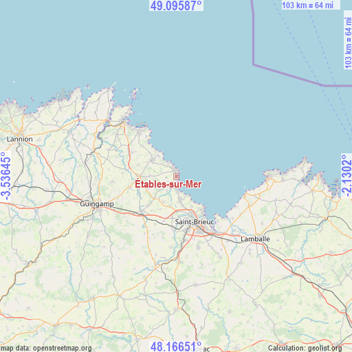
Étables-sur-Mer GPS coordinates[2]
48° 37' 59.988" North, 2° 49' 59.988" West
| Map corner | latitude | longitude |
|---|---|---|
| Upper-left | 49.09587°, | -3.53645° |
| Center: | 48.63333°, | -2.83333° |
| Lower-right: | 48.16651°, | -2.1302° |
| Map W x H: | 103.3×103.3 km | = 64.2×64.2mi |
| max Lat: | 51.07786° ⇑28.4% North |
| Étables-sur-Mer: | 48.63333° |
| min Lat: | ⇓71.6% South 41.3874° |
| min Long | Étables-sur-Me | max Long |
| -5.08615° | -2.83333° | 9.52242° |
| W 3.1%⇐ | ⇒96.9% E |
Elevation
Elevation of Étables-sur-Mer is 41 m = 135 ft, and this is 152.7 m = 501 ft below average elevation for this country.
| Max E: |
2333 m = 7654 ft | 85.3% |
| Avg. | 193.7 m = 635 ft | |
| Étables-sur-Mer | 41 m = 135 ft | |
Min E: |
-1 m = -3 ft | 14.7% |
See also: France elevation on elevation.city.
Geographical zone
Étables-sur-Mer is located in North temperate zone (between Tropic of Cancer and the Arctic Circle). Distance of this North polar circle is 1993.7 km =1238.8 mi to North.| Distance of | km | miles | from Étables-sur-Mer |
|---|---|---|---|
| North Pole | 4599.5 | 2858 | to North |
| Arctic Circle | 1993.7 | 1238.8 | to North |
| Tropic Cancer | 2801.6 | 1740.8 | to South |
| Equator | 5407.5 | 3360.1 | to South |


Nearby cities:
15 places around Étables-sur-Mer: (largest is in red/bold)
• Binic
3.7 km =2.3 mi,  171°
171°
• Lantic
4.7 km =2.9 mi,  230°
230°
• Lanvollon
11.3 km =7 mi,  268°
268°
• Plerneuf
13.6 km =8.5 mi,  195°
195°
• Plouha
8.5 km =5.3 mi,  304°
304°
• Pléguien
7.8 km =4.8 mi, 271°
• Plélo
12 km =7.5 mi,  223°
223°
• Plérin
10.8 km =6.7 mi,  158°
158°
• Pordic
7.1 km =4.4 mi, 170°
• Saint-Quay-Portrieux
1.9 km =1.2 mi,  6°
6°
• Tressignaux
11.3 km =7 mi,  260°
260°
• Trégomeur
8.3 km =5.2 mi,  206°
206°
• Tréguidel
8.8 km =5.5 mi,  246°
246°
• Trémuson
12.3 km =7.6 mi,  185°
185°
• Tréveneuc
4.4 km =2.7 mi,  323°
323°
Sources, notices
• [Note1] Compared only with cities in France existing in our database
• [Src1] Map data: © OpenStreetMap contributors (CC-BY-SA)
• [Src2] Other city data from geonames.org with taken over terms of usage.
• [Src3] Geographical zone / Annual Mean Temperature by Robert A. Rohde @ Wikipedia
