Trappes geodata
Trappes (Île-de-France) is a populated place; located in France in Europe/Paris (GMT+2) time zone. With population of 28,367 people, there are 297 cities with bigger population in this country. Compared to other cities in France, 74.9% of cities are located further ↓South; 56.9% of cities are located further →East and 60.7% of cities have lower elevation than Trappes. Note1
Administrative division(s):
- Level 1: Île-de-France
- Level 2: Yvelines
- Level 3: Arrondissement de Versailles
- Level 4: Trappes


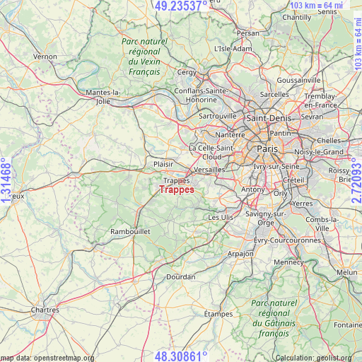
Trappes GPS coordinates[2]
48° 46' 26.868" North, 2° 1' 4.116" East
| Map corner | latitude | longitude |
|---|---|---|
| Upper-left | 49.23537°, | 1.31468° |
| Center: | 48.77413°, | 2.01781° |
| Lower-right: | 48.30861°, | 2.72093° |
| Map W x H: | 103×103 km | = 64×64mi |
| max Lat: | 51.07786° ⇑25.1% North |
| Trappes: | 48.77413° |
| min Lat: | ⇓74.9% South 41.3874° |
| min Long | Trappes | max Long |
| -5.08615° | 2.01781° | 9.52242° |
| W 43.1%⇐ | ⇒56.9% E |
Elevation
Elevation of Trappes is 173 m = 568 ft, and this is 20.7 m = 68 ft below average elevation for this country.
| Max E: |
2333 m = 7654 ft | 39.3% |
| Avg. | 193.7 m = 635 ft | |
| Trappes | 173 m = 568 ft | |
Min E: |
-1 m = -3 ft | 60.7% |
See also: France elevation on elevation.city.
Geographical zone
Trappes is located in North temperate zone (between Tropic of Cancer and the Arctic Circle). Distance of this North polar circle is 1978 km =1229.1 mi to North.| Distance of | km | miles | from Trappes |
|---|---|---|---|
| North Pole | 4583.9 | 2848.3 | to North |
| Arctic Circle | 1978 | 1229.1 | to North |
| Tropic Cancer | 2817.3 | 1750.6 | to South |
| Equator | 5423.2 | 3369.8 | to South |


Nearby cities:
15 places around Trappes: (largest is in red/bold)
• Bois-d’Arcy
2.9 km =1.8 mi,  7°
7°
• Châteaufort
6.8 km =4.2 mi,  128°
128°
• Fontenay-le-Fleury
4.8 km =3 mi,  27°
27°
• Guyancourt
4.1 km =2.5 mi,  91°
91°
• La Verrière
5.8 km =3.6 mi,  244°
244°
• Le Mesnil-Saint-Denis
5.6 km =3.5 mi,  234°
234°
• Les Clayes-sous-Bois
5.8 km =3.6 mi,  336°
336°
• Magny-les-Hameaux
4.7 km =2.9 mi,  136°
136°
• Maurepas
6.6 km =4.1 mi,  260°
260°
• Montigny-le-Bretonneux
1.5 km =0.9 mi, 125°
• Saint-Cyr-l’École
4.6 km =2.9 mi,  53°
53°
• Saint-Quentin-en-Yvelines
0.3 km =0.2 mi,  162°
162°
• Villepreux
6.2 km =3.9 mi,  346°
346°
• Voisins-le-Bretonneux
3 km =1.9 mi, 126°
• Élancourt
4.7 km =2.9 mi,  283°
283°
Sources, notices
• [Note1] Compared only with cities in France existing in our database
• [Src1] Map data: © OpenStreetMap contributors (CC-BY-SA)
• [Src2] Other city data from geonames.org with taken over terms of usage.
• [Src3] Geographical zone / Annual Mean Temperature by Robert A. Rohde @ Wikipedia
