Fontenay-le-Fleury geodata
Fontenay-le-Fleury (Île-de-France) is a populated place; located in France in Europe/Paris (GMT+2) time zone. With population of 12,611 people, there are 752 cities with bigger population in this country. Compared to other cities in France, 75.7% of cities are located further ↓South; 56.5% of cities are located further →East and 53.1% of cities have higher elevation than Fontenay-le-Fleury. Note1
Administrative division(s):
- Level 1: Île-de-France
- Level 2: Yvelines
- Level 3: Arrondissement de Versailles
- Level 4: Fontenay-le-Fleury


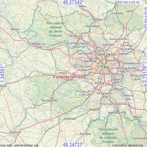
Fontenay-le-Fleury GPS coordinates[2]
48° 48' 45.108" North, 2° 2' 55.068" East
| Map corner | latitude | longitude |
|---|---|---|
| Upper-left | 49.27342°, | 1.34551° |
| Center: | 48.81253°, | 2.04863° |
| Lower-right: | 48.34737°, | 2.75176° |
| Map W x H: | 103×103 km | = 64×64mi |
| max Lat: | 51.07786° ⇑24.3% North |
| Fontenay-le-Fleury: | 48.81253° |
| min Lat: | ⇓75.7% South 41.3874° |
| min Long | Fontenay-le-Fle | max Long |
| -5.08615° | 2.04863° | 9.52242° |
| W 43.5%⇐ | ⇒56.5% E |
Elevation
Elevation of Fontenay-le-Fleury is 122 m = 400 ft, and this is 71.7 m = 235 ft below average elevation for this country.
| Max E: |
2333 m = 7654 ft | 53.1% |
| Avg. | 193.7 m = 635 ft | |
| Fontenay-le-Fleury | 122 m = 400 ft | |
Min E: |
-1 m = -3 ft | 46.9% |
See also: France elevation on elevation.city.
Geographical zone
Fontenay-le-Fleury is located in North temperate zone (between Tropic of Cancer and the Arctic Circle). Distance of this North polar circle is 1973.7 km =1226.4 mi to North.| Distance of | km | miles | from Fontenay-le-Fleury |
|---|---|---|---|
| North Pole | 4579.6 | 2845.6 | to North |
| Arctic Circle | 1973.7 | 1226.4 | to North |
| Tropic Cancer | 2821.5 | 1753.2 | to South |
| Equator | 5427.4 | 3372.4 | to South |


Nearby cities:
15 places around Fontenay-le-Fleury: (largest is in red/bold)
• Bailly
3.8 km =2.4 mi,  32°
32°
• Bois-d’Arcy
2.3 km =1.4 mi,  232°
232°
• Chavenay
6.2 km =3.9 mi,  318°
318°
• Guyancourt
4.7 km =2.9 mi,  156°
156°
• Le Chesnay
5.5 km =3.4 mi,  78°
78°
• Les Clayes-sous-Bois
4.7 km =2.9 mi,  283°
283°
• Montigny-le-Bretonneux
5.2 km =3.2 mi,  191°
191°
• Noisy-le-Roi
3.7 km =2.3 mi,  16°
16°
• Rocquencourt
4.8 km =3 mi,  54°
54°
• Saint-Cyr-l’École
2.1 km =1.3 mi,  137°
137°
• Saint-Nom-la-Bretêche
5.6 km =3.5 mi,  339°
339°
• Saint-Quentin-en-Yvelines
5 km =3.1 mi,  205°
205°
• Trappes
4.8 km =3 mi, 207°
• Villepreux
4.1 km =2.5 mi,  294°
294°
• Voisins-le-Bretonneux
6.1 km =3.8 mi,  178°
178°
Sources, notices
• [Note1] Compared only with cities in France existing in our database
• [Src1] Map data: © OpenStreetMap contributors (CC-BY-SA)
• [Src2] Other city data from geonames.org with taken over terms of usage.
• [Src3] Geographical zone / Annual Mean Temperature by Robert A. Rohde @ Wikipedia
