Les Clayes-sous-Bois geodata
Les Clayes-sous-Bois (Île-de-France) is a populated place; located in France in Europe/Paris (GMT+2) time zone. With population of 17,776 people, there are 535 cities with bigger population in this country. Compared to other cities in France, 76% of cities are located further ↓South; 57.3% of cities are located further →East and 50.1% of cities have lower elevation than Les Clayes-sous-Bois. Note1
Administrative division(s):
- Level 1: Île-de-France
- Level 2: Yvelines
- Level 3: Arrondissement de Versailles
- Level 4: Les Clayes-sous-Bois


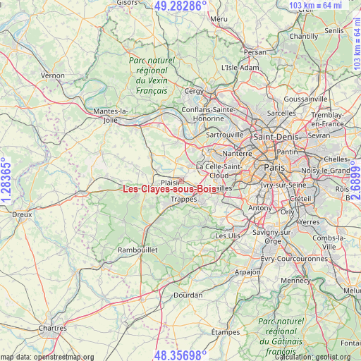
Les Clayes-sous-Bois GPS coordinates[2]
48° 49' 19.416" North, 1° 59' 12.372" East
| Map corner | latitude | longitude |
|---|---|---|
| Upper-left | 49.28286°, | 1.28365° |
| Center: | 48.82206°, | 1.98677° |
| Lower-right: | 48.35698°, | 2.6899° |
| Map W x H: | 102.9×102.9 km | = 63.9×63.9mi |
| max Lat: | 51.07786° ⇑24% North |
| Les Clayes-sous-Bois: | 48.82206° |
| min Lat: | ⇓76% South 41.3874° |
| min Long | Les Clayes-sous | max Long |
| -5.08615° | 1.98677° | 9.52242° |
| W 42.7%⇐ | ⇒57.3% E |
Elevation
Elevation of Les Clayes-sous-Bois is 132 m = 433 ft, and this is 61.7 m = 202 ft below average elevation for this country.
| Max E: |
2333 m = 7654 ft | 49.9% |
| Avg. | 193.7 m = 635 ft | |
| Les Clayes-sous-Bois | 132 m = 433 ft | |
Min E: |
-1 m = -3 ft | 50.1% |
See also: France elevation on elevation.city.
Geographical zone
Les Clayes-sous-Bois is located in North temperate zone (between Tropic of Cancer and the Arctic Circle). Distance of this North polar circle is 1972.7 km =1225.8 mi to North.| Distance of | km | miles | from Les Clayes-sous-Bois |
|---|---|---|---|
| North Pole | 4578.6 | 2845 | to North |
| Arctic Circle | 1972.7 | 1225.8 | to North |
| Tropic Cancer | 2822.6 | 1753.9 | to South |
| Equator | 5428.5 | 3373.1 | to South |


Nearby cities:
15 places around Les Clayes-sous-Bois: (largest is in red/bold)
• Bois-d’Arcy
3.7 km =2.3 mi,  132°
132°
• Chavenay
3.6 km =2.2 mi,  5°
5°
• Feucherolles
5.4 km =3.4 mi,  350°
350°
• Fontenay-le-Fleury
4.7 km =2.9 mi,  103°
103°
• Neauphle-le-Château
6 km =3.7 mi,  261°
261°
• Noisy-le-Roi
6.1 km =3.8 mi,  66°
66°
• Plaisir
2.4 km =1.5 mi,  273°
273°
• Saint-Cyr-l’École
6.5 km =4 mi,  113°
113°
• Saint-Germain-de-la-Grange
6.6 km =4.1 mi,  281°
281°
• Saint-Nom-la-Bretêche
4.9 km =3 mi,  32°
32°
• Saint-Quentin-en-Yvelines
6.1 km =3.8 mi,  157°
157°
• Thiverval-Grignon
5.9 km =3.7 mi,  301°
301°
• Trappes
5.8 km =3.6 mi, 156°
• Villepreux
1 km =0.6 mi,  49°
49°
• Élancourt
4.8 km =3 mi,  208°
208°
Sources, notices
• [Note1] Compared only with cities in France existing in our database
• [Src1] Map data: © OpenStreetMap contributors (CC-BY-SA)
• [Src2] Other city data from geonames.org with taken over terms of usage.
• [Src3] Geographical zone / Annual Mean Temperature by Robert A. Rohde @ Wikipedia
