Élancourt geodata
Élancourt (Île-de-France) is a populated place; located in France in Europe/Paris (GMT+2) time zone. With population of 30,831 people, there are 262 cities with bigger population in this country. Compared to other cities in France, 75.2% of cities are located further ↓South; 57.6% of cities are located further →East and 50.3% of cities have lower elevation than Élancourt. Note1
Administrative division(s):
- Level 1: Île-de-France
- Level 2: Yvelines
- Level 3: Arrondissement de Rambouillet
- Level 4: Élancourt


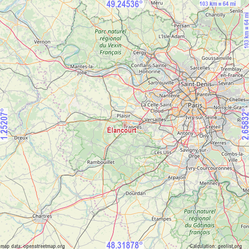
Élancourt GPS coordinates[2]
48° 47' 3.156" North, 1° 57' 18.72" East
| Map corner | latitude | longitude |
|---|---|---|
| Upper-left | 49.24536°, | 1.25207° |
| Center: | 48.78421°, | 1.9552° |
| Lower-right: | 48.31878°, | 2.65832° |
| Map W x H: | 103×103 km | = 64×64mi |
| max Lat: | 51.07786° ⇑24.8% North |
| Élancourt: | 48.78421° |
| min Lat: | ⇓75.2% South 41.3874° |
| min Long | Élancourt | max Long |
| -5.08615° | 1.9552° | 9.52242° |
| W 42.4%⇐ | ⇒57.6% E |
Elevation
Elevation of Élancourt is 133 m = 436 ft, and this is 60.7 m = 199 ft below average elevation for this country.
| Max E: |
2333 m = 7654 ft | 49.7% |
| Avg. | 193.7 m = 635 ft | |
| Élancourt | 133 m = 436 ft | |
Min E: |
-1 m = -3 ft | 50.3% |
See also: France elevation on elevation.city.
Geographical zone
Élancourt is located in North temperate zone (between Tropic of Cancer and the Arctic Circle). Distance of this North polar circle is 1976.9 km =1228.4 mi to North.| Distance of | km | miles | from Élancourt |
|---|---|---|---|
| North Pole | 4582.8 | 2847.6 | to North |
| Arctic Circle | 1976.9 | 1228.4 | to North |
| Tropic Cancer | 2818.4 | 1751.3 | to South |
| Equator | 5424.3 | 3370.5 | to South |


Nearby cities:
15 places around Élancourt: (largest is in red/bold)
• Bois-d’Arcy
5.3 km =3.3 mi,  70°
70°
• Coignières
4.6 km =2.9 mi,  213°
213°
• Jouars-Pontchartrain
4.2 km =2.6 mi,  277°
277°
• La Verrière
3.6 km =2.2 mi,  190°
190°
• Le Mesnil-Saint-Denis
4.4 km =2.7 mi,  179°
179°
• Le Tremblay-sur-Mauldre
5.7 km =3.5 mi,  263°
263°
• Les Clayes-sous-Bois
4.8 km =3 mi,  28°
28°
• Maurepas
2.9 km =1.8 mi,  221°
221°
• Montigny-le-Bretonneux
6.1 km =3.8 mi,  108°
108°
• Neauphle-le-Château
4.9 km =3 mi,  312°
312°
• Plaisir
4.3 km =2.7 mi,  358°
358°
• Saint-Quentin-en-Yvelines
4.9 km =3 mi, 106°
• Trappes
4.7 km =2.9 mi,  103°
103°
• Villepreux
5.8 km =3.6 mi, 32°
• Villiers-Saint-Fréderic
6.4 km =4 mi,  304°
304°
Sources, notices
• [Note1] Compared only with cities in France existing in our database
• [Src1] Map data: © OpenStreetMap contributors (CC-BY-SA)
• [Src2] Other city data from geonames.org with taken over terms of usage.
• [Src3] Geographical zone / Annual Mean Temperature by Robert A. Rohde @ Wikipedia
