Tracy-le-Mont geodata
Tracy-le-Mont (Hauts-de-France) is a populated place; located in France in Europe/Paris (GMT+2) time zone. With population of 1,772 people, there are 5351 cities with bigger population in this country. Compared to other cities in France, 88.9% of cities are located further ↓South; 57.9% of cities are located further ←West and 56.5% of cities have higher elevation than Tracy-le-Mont. Note1
Administrative division(s):
- Level 1: Hauts-de-France
- Level 2: Département de l'Oise
- Level 3: Arrondissement de Compiègne
- Level 4: Tracy-le-Mont


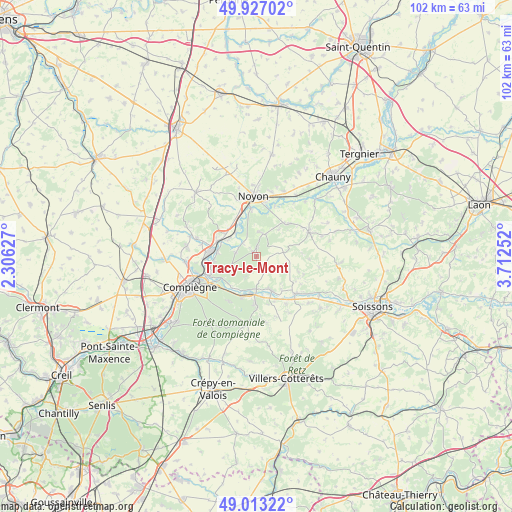
Tracy-le-Mont GPS coordinates[2]
49° 28' 20.1" North, 3° 0' 33.804" East
| Map corner | latitude | longitude |
|---|---|---|
| Upper-left | 49.92702°, | 2.30627° |
| Center: | 49.47225°, | 3.00939° |
| Lower-right: | 49.01322°, | 3.71252° |
| Map W x H: | 101.6×101.6 km | = 63.1×63.1mi |
| max Lat: | 51.07786° ⇑11.1% North |
| Tracy-le-Mont: | 49.47225° |
| min Lat: | ⇓88.9% South 41.3874° |
| min Long | Tracy-le-Mont | max Long |
| -5.08615° | 3.00939° | 9.52242° |
| W 57.9%⇐ | ⇒42.1% E |
Elevation
Elevation of Tracy-le-Mont is 112 m = 367 ft, and this is 81.7 m = 268 ft below average elevation for this country.
| Max E: |
2333 m = 7654 ft | 56.5% |
| Avg. | 193.7 m = 635 ft | |
| Tracy-le-Mont | 112 m = 367 ft | |
Min E: |
-1 m = -3 ft | 43.5% |
See also: France elevation on elevation.city.
Geographical zone
Tracy-le-Mont is located in North temperate zone (between Tropic of Cancer and the Arctic Circle). Distance of this North polar circle is 1900.4 km =1180.9 mi to North.| Distance of | km | miles | from Tracy-le-Mont |
|---|---|---|---|
| North Pole | 4506.3 | 2800.1 | to North |
| Arctic Circle | 1900.4 | 1180.9 | to North |
| Tropic Cancer | 2894.9 | 1798.8 | to South |
| Equator | 5500.8 | 3418 | to South |


Nearby cities:
15 places around Tracy-le-Mont: (largest is in red/bold)
• Attichy
7.4 km =4.6 mi,  156°
156°
• Autrêches
8.9 km =5.5 mi,  110°
110°
• Bailly
3.9 km =2.4 mi,  312°
312°
• Berneuil-sur-Aisne
6.4 km =4 mi,  180°
180°
• Cambronne-lès-Ribécourt
8.9 km =5.5 mi,  295°
295°
• Carlepont
4.8 km =3 mi,  12°
12°
• Couloisy
8.2 km =5.1 mi,  170°
170°
• Dreslincourt
8.6 km =5.3 mi,  316°
316°
• Le Plessis-Brion
8.6 km =5.3 mi,  264°
264°
• Montmacq
7.8 km =4.8 mi,  277°
277°
• Pimprez
6.3 km =3.9 mi, 318°
• Rethondes
8.1 km =5 mi,  219°
219°
• Saint-Léger-aux-Bois
4.1 km =2.5 mi,  287°
287°
• Tracy-le-Val
1.8 km =1.1 mi,  359°
359°
• Trosly-Breuil
8.6 km =5.3 mi,  201°
201°
Sources, notices
• [Note1] Compared only with cities in France existing in our database
• [Src1] Map data: © OpenStreetMap contributors (CC-BY-SA)
• [Src2] Other city data from geonames.org with taken over terms of usage.
• [Src3] Geographical zone / Annual Mean Temperature by Robert A. Rohde @ Wikipedia
