Saint-Pierre-des-Échaubrognes geodata
Saint-Pierre-des-Échaubrognes (Nouvelle-Aquitaine) is a populated place; located in France in Europe/Paris (GMT+2) time zone. With population of 1,290 people, there are 7081 cities with bigger population in this country. Compared to other cities in France, 55.4% of cities are located further ↑North; 85.9% of cities are located further →East and 55.6% of cities have lower elevation than Saint-Pierre-des-Échaubrognes. Note1
Administrative division(s):
- Level 1: Nouvelle-Aquitaine
- Level 2: Département des Deux-Sèvres
- Level 3: Arrondissement de Bressuire
- Level 4: Saint-Pierre-des-Échaubrognes
Current local time in Saint-Pierre-des-Échaubrognes:
07:18 AM, SaturdayDifference from your time zone: hours


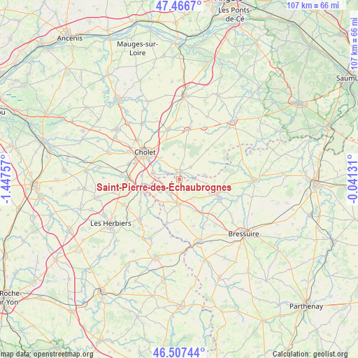
Saint-Pierre-des-Échaubrognes GPS coordinates[2]
46° 59' 21.192" North, 0° 44' 39.984" West
| Map corner | latitude | longitude |
|---|---|---|
| Upper-left | 47.4667°, | -1.44757° |
| Center: | 46.98922°, | -0.74444° |
| Lower-right: | 46.50744°, | -0.04131° |
| Map W x H: | 106.7×106.7 km | = 66.3×66.3mi |
| max Lat: | 51.07786° ⇑55.4% North |
| Saint-Pierre-des-Échaubrognes: | 46.98922° |
| min Lat: | ⇓44.6% South 41.3874° |
| min Long | Saint-Pierre-de | max Long |
| -5.08615° | -0.74444° | 9.52242° |
| W 14.1%⇐ | ⇒85.9% E |
Elevation
Elevation of Saint-Pierre-des-Échaubrognes is 152 m = 499 ft, and this is 41.7 m = 137 ft below average elevation for this country.
| Max E: |
2333 m = 7654 ft | 44.4% |
| Avg. | 193.7 m = 635 ft | |
| Saint-Pierre-des-Échaubrognes | 152 m = 499 ft | |
Min E: |
-1 m = -3 ft | 55.6% |
See also: France elevation on elevation.city.
Geographical zone
Saint-Pierre-des-Échaubrognes is located in North temperate zone (between Tropic of Cancer and the Arctic Circle). Distance of this North polar circle is 2176.5 km =1352.4 mi to North.| Distance of | km | miles | from Saint-Pierre-des-Échaubrognes |
|---|---|---|---|
| North Pole | 4782.4 | 2971.6 | to North |
| Arctic Circle | 2176.5 | 1352.4 | to North |
| Tropic Cancer | 2618.8 | 1627.2 | to South |
| Equator | 5224.7 | 3246.5 | to South |


Nearby cities:
15 places around Saint-Pierre-des-Échaubrognes: (largest is in red/bold)
• Chanteloup-les-Bois
12.6 km =7.8 mi,  21°
21°
• Cholet
12.9 km =8 mi,  307°
307°
• La Petite-Boissière
11.7 km =7.3 mi,  179°
179°
• La Plaine
12 km =7.5 mi,  43°
43°
• La Tessoualle
8.3 km =5.2 mi,  282°
282°
• Maulévrier
2.2 km =1.4 mi,  3°
3°
• Mazières-en-Mauges
8.3 km =5.2 mi,  318°
318°
• Nuaillé
12.4 km =7.7 mi,  342°
342°
• Nueil-les-Aubiers
13.7 km =8.5 mi,  116°
116°
• Saint-Laurent-sur-Sèvre
11.9 km =7.4 mi,  253°
253°
• Saint-Malô-du-Bois
13.3 km =8.3 mi,  242°
242°
• Somloire
11.4 km =7.1 mi,  65°
65°
• Toutlemonde
7.5 km =4.7 mi,  347°
347°
• Treize-Vents
11 km =6.8 mi,  226°
226°
• Yzernay
4.8 km =3 mi, 40°
Sources, notices
• [Note1] Compared only with cities in France existing in our database
• [Src1] Map data: © OpenStreetMap contributors (CC-BY-SA)
• [Src2] Other city data from geonames.org with taken over terms of usage.
• [Src3] Geographical zone / Annual Mean Temperature by Robert A. Rohde @ Wikipedia
