Pulnoy geodata
Pulnoy (Grand Est) is a populated place; located in France in Europe/Paris (GMT+2) time zone. With population of 4,842 people, there are 2049 cities with bigger population in this country. Compared to other cities in France, 73.3% of cities are located further ↓South; 89.8% of cities are located further ←West and 70.6% of cities have lower elevation than Pulnoy. Note1
Administrative division(s):
- Level 1: Grand Est
- Level 2: Meurthe-et-Moselle
- Level 3: Arrondissement de Nancy
- Level 4: Pulnoy


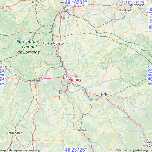
Pulnoy GPS coordinates[2]
48° 42' 12.348" North, 6° 15' 27.54" East
| Map corner | latitude | longitude |
|---|---|---|
| Upper-left | 49.16532°, | 5.55453° |
| Center: | 48.70343°, | 6.25765° |
| Lower-right: | 48.23726°, | 6.96078° |
| Map W x H: | 103.2×103.2 km | = 64.1×64.1mi |
| max Lat: | 51.07786° ⇑26.7% North |
| Pulnoy: | 48.70343° |
| min Lat: | ⇓73.3% South 41.3874° |
| min Long | Pulnoy | max Long |
| -5.08615° | 6.25765° | 9.52242° |
| W 89.8%⇐ | ⇒10.2% E |
Elevation
Elevation of Pulnoy is 222 m = 728 ft, and this is 28.3 m = 93 ft above average elevation for this country.
| Max E: |
2333 m = 7654 ft | 29.4% |
| Pulnoy | 222 m 728 ft | |
| Avg. | 193.7 m = 635 ft | |
Min E: |
-1 m = -3 ft | 70.6% |
See also: France elevation on elevation.city.
Geographical zone
Pulnoy is located in North temperate zone (between Tropic of Cancer and the Arctic Circle). Distance of this North polar circle is 1985.9 km =1234 mi to North.| Distance of | km | miles | from Pulnoy |
|---|---|---|---|
| North Pole | 4591.7 | 2853.1 | to North |
| Arctic Circle | 1985.9 | 1234 | to North |
| Tropic Cancer | 2809.4 | 1745.7 | to South |
| Equator | 5415.3 | 3364.9 | to South |


Nearby cities:
15 places around Pulnoy: (largest is in red/bold)
• Art-sur-Meurthe
5.2 km =3.2 mi,  172°
172°
• Cerville
4.1 km =2.5 mi,  101°
101°
• Dommartemont
3.3 km =2.1 mi,  289°
289°
• Essey-lès-Nancy
2.3 km =1.4 mi,  274°
274°
• Eulmont
5.7 km =3.5 mi,  336°
336°
• Jarville-la-Malgrange
5.7 km =3.5 mi,  224°
224°
• Laneuveville-devant-Nancy
5.7 km =3.5 mi,  203°
203°
• Lay-Saint-Christophe
6.7 km =4.2 mi,  319°
319°
• Malzéville
5.4 km =3.4 mi,  280°
280°
• Maxéville
6.8 km =4.2 mi, 279°
• Nancy
5.7 km =3.5 mi,  248°
248°
• Saint-Max
3.7 km =2.3 mi, 271°
• Saulxures-lès-Nancy
1.9 km =1.2 mi,  212°
212°
• Seichamps
1.3 km =0.8 mi,  12°
12°
• Tomblaine
3.7 km =2.3 mi,  234°
234°
Sources, notices
• [Note1] Compared only with cities in France existing in our database
• [Src1] Map data: © OpenStreetMap contributors (CC-BY-SA)
• [Src2] Other city data from geonames.org with taken over terms of usage.
• [Src3] Geographical zone / Annual Mean Temperature by Robert A. Rohde @ Wikipedia
