Thoiry geodata
Thoiry (Auvergne-Rhône-Alpes) is a populated place; located in France in Europe/Paris (GMT+2) time zone. With population of 4,433 people, there are 2227 cities with bigger population in this country. Compared to other cities in France, 63% of cities are located further ↑North; 86.9% of cities are located further ←West and 92.5% of cities have lower elevation than Thoiry. Note1
Administrative division(s):
- Level 1: Auvergne-Rhône-Alpes
- Level 2: Département de l'Ain
- Level 3: Arrondissement de Gex
- Level 4: Thoiry


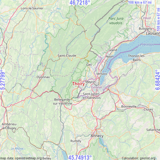
Thoiry GPS coordinates[2]
46° 14' 15.432" North, 5° 58' 51.996" East
| Map corner | latitude | longitude |
|---|---|---|
| Upper-left | 46.7218°, | 5.27799° |
| Center: | 46.23762°, | 5.98111° |
| Lower-right: | 45.74913°, | 6.68424° |
| Map W x H: | 108.2×108.1 km | = 67.2×67.2mi |
| max Lat: | 51.07786° ⇑63% North |
| Thoiry: | 46.23762° |
| min Lat: | ⇓37% South 41.3874° |
| min Long | Thoiry | max Long |
| -5.08615° | 5.98111° | 9.52242° |
| W 86.9%⇐ | ⇒13.1% E |
Elevation
Elevation of Thoiry is 489 m = 1604 ft, and this is 295.3 m = 969 ft above average elevation for this country.
| Max E: |
2333 m = 7654 ft | 7.5% |
| Thoiry | 489 m 1604 ft | |
| Avg. | 193.7 m = 635 ft | |
Min E: |
-1 m = -3 ft | 92.5% |
See also: France elevation on elevation.city.
Geographical zone
Thoiry is located in North temperate zone (between Tropic of Cancer and the Arctic Circle). Distance of this North polar circle is 2260 km =1404.3 mi to North.| Distance of | km | miles | from Thoiry |
|---|---|---|---|
| North Pole | 4865.9 | 3023.5 | to North |
| Arctic Circle | 2260 | 1404.3 | to North |
| Tropic Cancer | 2535.2 | 1575.3 | to South |
| Equator | 5141.1 | 3194.5 | to South |


Nearby cities:
15 places around Thoiry: (largest is in red/bold)
• Cessy
11.7 km =7.3 mi,  38°
38°
• Challex
5.9 km =3.7 mi,  183°
183°
• Chevry
6.6 km =4.1 mi, 42°
• Collonges
12.5 km =7.8 mi,  207°
207°
• Farges
9.8 km =6.1 mi,  216°
216°
• Ferney-Voltaire
10.2 km =6.3 mi,  76°
76°
• Gex
12.1 km =7.5 mi,  28°
28°
• Ornex
9.9 km =6.2 mi,  66°
66°
• Pougny
11.1 km =6.9 mi,  192°
192°
• Péron
6.8 km =4.2 mi, 219°
• Saint-Genis-Pouilly
3.2 km =2 mi, 77°
• Saint-Jean-de-Gonville
3.6 km =2.2 mi, 220°
• Sergy
2.2 km =1.4 mi,  47°
47°
• Ségny
9.5 km =5.9 mi, 47°
• Échenevex
9.1 km =5.7 mi, 29°
Sources, notices
• [Note1] Compared only with cities in France existing in our database
• [Src1] Map data: © OpenStreetMap contributors (CC-BY-SA)
• [Src2] Other city data from geonames.org with taken over terms of usage.
• [Src3] Geographical zone / Annual Mean Temperature by Robert A. Rohde @ Wikipedia
