Chevry geodata
Chevry (Auvergne-Rhône-Alpes) is a populated place; located in France in Europe/Paris (GMT+2) time zone. With population of 1,126 people, there are 7971 cities with bigger population in this country. Compared to other cities in France, 62.5% of cities are located further ↑North; 87.5% of cities are located further ←West and 91.9% of cities have lower elevation than Chevry. Note1
Administrative division(s):
- Level 1: Auvergne-Rhône-Alpes
- Level 2: Département de l'Ain
- Level 3: Arrondissement de Gex
- Level 4: Chevry


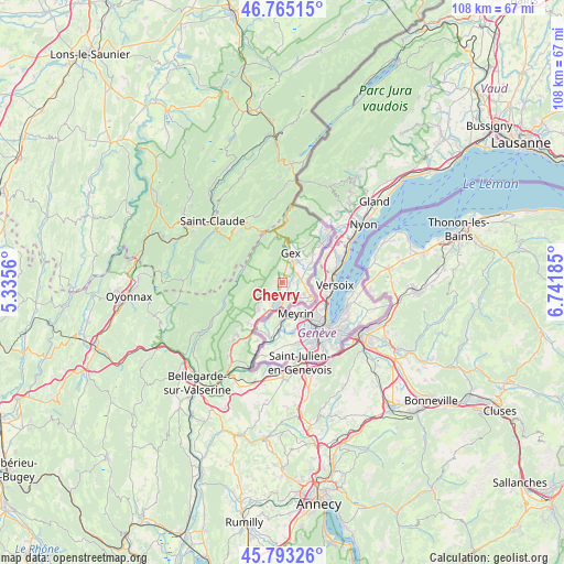
Chevry GPS coordinates[2]
46° 16' 52.896" North, 6° 2' 19.428" East
| Map corner | latitude | longitude |
|---|---|---|
| Upper-left | 46.76515°, | 5.3356° |
| Center: | 46.28136°, | 6.03873° |
| Lower-right: | 45.79326°, | 6.74185° |
| Map W x H: | 108.1×108.1 km | = 67.2×67.2mi |
| max Lat: | 51.07786° ⇑62.5% North |
| Chevry: | 46.28136° |
| min Lat: | ⇓37.5% South 41.3874° |
| min Long | Chevry | max Long |
| -5.08615° | 6.03873° | 9.52242° |
| W 87.5%⇐ | ⇒12.5% E |
Elevation
Elevation of Chevry is 474 m = 1555 ft, and this is 280.3 m = 920 ft above average elevation for this country.
| Max E: |
2333 m = 7654 ft | 8.1% |
| Chevry | 474 m 1555 ft | |
| Avg. | 193.7 m = 635 ft | |
Min E: |
-1 m = -3 ft | 91.9% |
See also: France elevation on elevation.city.
Geographical zone
Chevry is located in North temperate zone (between Tropic of Cancer and the Arctic Circle). Distance of this North polar circle is 2255.2 km =1401.3 mi to North.| Distance of | km | miles | from Chevry |
|---|---|---|---|
| North Pole | 4861.1 | 3020.5 | to North |
| Arctic Circle | 2255.2 | 1401.3 | to North |
| Tropic Cancer | 2540.1 | 1578.3 | to South |
| Equator | 5146 | 3197.6 | to South |


Nearby cities:
15 places around Chevry: (largest is in red/bold)
• Cessy
5.1 km =3.2 mi,  32°
32°
• Challex
11.8 km =7.3 mi,  204°
204°
• Divonne-les-Bains
11.2 km =7 mi,  41°
41°
• Ferney-Voltaire
6.1 km =3.8 mi,  114°
114°
• Gex
5.9 km =3.7 mi,  14°
14°
• Grilly
8 km =5 mi,  46°
46°
• Ornex
4.8 km =3 mi,  101°
101°
• Péron
13.3 km =8.3 mi,  220°
220°
• Saint-Genis-Pouilly
4.4 km =2.7 mi, 197°
• Saint-Jean-de-Gonville
10.2 km =6.3 mi, 221°
• Sauverny
7.2 km =4.5 mi,  58°
58°
• Sergy
4.4 km =2.7 mi, 219°
• Ségny
3.1 km =1.9 mi, 58°
• Thoiry
6.6 km =4.1 mi, 222°
• Échenevex
3.1 km =1.9 mi,  1°
1°
Sources, notices
• [Note1] Compared only with cities in France existing in our database
• [Src1] Map data: © OpenStreetMap contributors (CC-BY-SA)
• [Src2] Other city data from geonames.org with taken over terms of usage.
• [Src3] Geographical zone / Annual Mean Temperature by Robert A. Rohde @ Wikipedia
