Saint-Jean-de-Gonville geodata
Saint-Jean-de-Gonville (Auvergne-Rhône-Alpes) is a populated place; located in France in Europe/Paris (GMT+2) time zone. With population of 1,297 people, there are 7046 cities with bigger population in this country. Compared to other cities in France, 63.4% of cities are located further ↑North; 86.5% of cities are located further ←West and 93.5% of cities have lower elevation than Saint-Jean-de-Gonville. Note1
Administrative division(s):
- Level 1: Auvergne-Rhône-Alpes
- Level 2: Département de l'Ain
- Level 3: Arrondissement de Gex
- Level 4: Saint-Jean-de-Gonville
Current local time in Saint-Jean-de-Gonville:
11:26 AM, SaturdayDifference from your time zone: hours


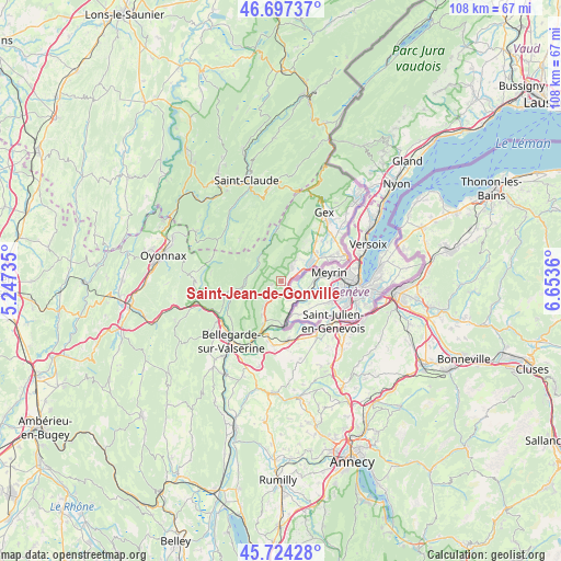
Saint-Jean-de-Gonville GPS coordinates[2]
46° 12' 46.728" North, 5° 57' 1.692" East
| Map corner | latitude | longitude |
|---|---|---|
| Upper-left | 46.69737°, | 5.24735° |
| Center: | 46.21298°, | 5.95047° |
| Lower-right: | 45.72428°, | 6.6536° |
| Map W x H: | 108.2×108.2 km | = 67.2×67.2mi |
| max Lat: | 51.07786° ⇑63.4% North |
| Saint-Jean-de-Gonville: | 46.21298° |
| min Lat: | ⇓36.6% South 41.3874° |
| min Long | Saint-Jean-de-G | max Long |
| -5.08615° | 5.95047° | 9.52242° |
| W 86.5%⇐ | ⇒13.5% E |
Elevation
Elevation of Saint-Jean-de-Gonville is 522 m = 1713 ft, and this is 328.3 m = 1077 ft above average elevation for this country.
| Max E: |
2333 m = 7654 ft | 6.5% |
| Saint-Jean-de-Gonville | 522 m 1713 ft | |
| Avg. | 193.7 m = 635 ft | |
Min E: |
-1 m = -3 ft | 93.5% |
See also: France elevation on elevation.city.
Geographical zone
Saint-Jean-de-Gonville is located in North temperate zone (between Tropic of Cancer and the Arctic Circle). Distance of this North polar circle is 2262.8 km =1406 mi to North.| Distance of | km | miles | from Saint-Jean-de-Gonville |
|---|---|---|---|
| North Pole | 4868.7 | 3025.3 | to North |
| Arctic Circle | 2262.8 | 1406 | to North |
| Tropic Cancer | 2532.5 | 1573.6 | to South |
| Equator | 5138.4 | 3192.9 | to South |


Nearby cities:
15 places around Saint-Jean-de-Gonville: (largest is in red/bold)
• Challex
3.7 km =2.3 mi,  147°
147°
• Champfromier
10.7 km =6.6 mi,  258°
258°
• Chevry
10.2 km =6.3 mi,  41°
41°
• Collonges
9 km =5.6 mi,  202°
202°
• Confort
12 km =7.5 mi,  234°
234°
• Farges
6.2 km =3.9 mi,  214°
214°
• Pougny
8.1 km =5 mi,  180°
180°
• Péron
3.2 km =2 mi,  217°
217°
• Saint-Genis-Pouilly
6.4 km =4 mi,  57°
57°
• Saint-Julien-en-Genevois
12.7 km =7.9 mi,  126°
126°
• Sergy
5.8 km =3.6 mi, 43°
• Thoiry
3.6 km =2.2 mi, 40°
• Valleiry
11.4 km =7.1 mi,  172°
172°
• Vulbens
12.5 km =7.8 mi,  185°
185°
• Échenevex
12.7 km =7.9 mi,  32°
32°
Sources, notices
• [Note1] Compared only with cities in France existing in our database
• [Src1] Map data: © OpenStreetMap contributors (CC-BY-SA)
• [Src2] Other city data from geonames.org with taken over terms of usage.
• [Src3] Geographical zone / Annual Mean Temperature by Robert A. Rohde @ Wikipedia
