Sergy geodata
Sergy (Auvergne-Rhône-Alpes) is a populated place; located in France in Europe/Paris (GMT+2) time zone. With population of 1,366 people, there are 6739 cities with bigger population in this country. Compared to other cities in France, 62.9% of cities are located further ↑North; 87.1% of cities are located further ←West and 91.3% of cities have lower elevation than Sergy. Note1
Administrative division(s):
- Level 1: Auvergne-Rhône-Alpes
- Level 2: Département de l'Ain
- Level 3: Arrondissement de Gex
- Level 4: Sergy


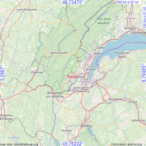
Sergy GPS coordinates[2]
46° 15' 2.484" North, 6° 0' 6.588" East
| Map corner | latitude | longitude |
|---|---|---|
| Upper-left | 46.73475°, | 5.2987° |
| Center: | 46.25069°, | 6.00183° |
| Lower-right: | 45.76232°, | 6.70495° |
| Map W x H: | 108.1×108.1 km | = 67.2×67.2mi |
| max Lat: | 51.07786° ⇑62.9% North |
| Sergy: | 46.25069° |
| min Lat: | ⇓37.1% South 41.3874° |
| min Long | Sergy | max Long |
| -5.08615° | 6.00183° | 9.52242° |
| W 87.1%⇐ | ⇒12.9% E |
Elevation
Elevation of Sergy is 458 m = 1503 ft, and this is 264.3 m = 867 ft above average elevation for this country.
| Max E: |
2333 m = 7654 ft | 8.7% |
| Sergy | 458 m 1503 ft | |
| Avg. | 193.7 m = 635 ft | |
Min E: |
-1 m = -3 ft | 91.3% |
See also: France elevation on elevation.city.
Geographical zone
Sergy is located in North temperate zone (between Tropic of Cancer and the Arctic Circle). Distance of this North polar circle is 2258.6 km =1403.4 mi to North.| Distance of | km | miles | from Sergy |
|---|---|---|---|
| North Pole | 4864.5 | 3022.7 | to North |
| Arctic Circle | 2258.6 | 1403.4 | to North |
| Tropic Cancer | 2536.7 | 1576.2 | to South |
| Equator | 5142.6 | 3195.5 | to South |


Nearby cities:
15 places around Sergy: (largest is in red/bold)
• Cessy
9.6 km =6 mi,  35°
35°
• Challex
7.6 km =4.7 mi,  194°
194°
• Chevry
4.4 km =2.7 mi, 39°
• Farges
11.9 km =7.4 mi,  218°
218°
• Ferney-Voltaire
8.4 km =5.2 mi,  84°
84°
• Gex
10.1 km =6.3 mi,  25°
25°
• Grilly
12.4 km =7.7 mi, 43°
• Ornex
7.9 km =4.9 mi,  72°
72°
• Péron
8.9 km =5.5 mi, 221°
• Saint-Genis-Pouilly
1.7 km =1.1 mi,  118°
118°
• Saint-Jean-de-Gonville
5.8 km =3.6 mi, 223°
• Sauverny
11.5 km =7.1 mi,  51°
51°
• Ségny
7.4 km =4.6 mi, 47°
• Thoiry
2.2 km =1.4 mi,  227°
227°
• Échenevex
7.1 km =4.4 mi,  24°
24°
Sources, notices
• [Note1] Compared only with cities in France existing in our database
• [Src1] Map data: © OpenStreetMap contributors (CC-BY-SA)
• [Src2] Other city data from geonames.org with taken over terms of usage.
• [Src3] Geographical zone / Annual Mean Temperature by Robert A. Rohde @ Wikipedia
