Chavannes-sur-Suran geodata
Chavannes-sur-Suran (Auvergne-Rhône-Alpes) is a populated place; located in France in Europe/Paris (GMT+2) time zone. With population of 529 people, there are 14624 cities with bigger population in this country. Compared to other cities in France, 62.8% of cities are located further ↑North; 82.2% of cities are located further ←West and 88% of cities have lower elevation than Chavannes-sur-Suran. Note1
Administrative division(s):
- Level 1: Auvergne-Rhône-Alpes
- Level 2: Département de l'Ain
- Level 3: Arrondissement de Bourg-en-Bresse
- Level 4: Nivigne et Suran


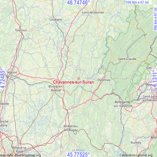
Chavannes-sur-Suran GPS coordinates[2]
46° 15' 48.636" North, 5° 25' 40.728" East
| Map corner | latitude | longitude |
|---|---|---|
| Upper-left | 46.74746°, | 4.72485° |
| Center: | 46.26351°, | 5.42798° |
| Lower-right: | 45.77525°, | 6.1311° |
| Map W x H: | 108.1×108.1 km | = 67.2×67.2mi |
| max Lat: | 51.07786° ⇑62.8% North |
| Chavannes-sur-Suran: | 46.26351° |
| min Lat: | ⇓37.2% South 41.3874° |
| min Long | Chavannes-sur-S | max Long |
| -5.08615° | 5.42798° | 9.52242° |
| W 82.2%⇐ | ⇒17.8% E |
Elevation
Elevation of Chavannes-sur-Suran is 389 m = 1276 ft, and this is 195.3 m = 641 ft above average elevation for this country.
| Max E: |
2333 m = 7654 ft | 12% |
| Chavannes-sur-Suran | 389 m 1276 ft | |
| Avg. | 193.7 m = 635 ft | |
Min E: |
-1 m = -3 ft | 88% |
See also: France elevation on elevation.city.
Geographical zone
Chavannes-sur-Suran is located in North temperate zone (between Tropic of Cancer and the Arctic Circle). Distance of this North polar circle is 2257.2 km =1402.6 mi to North.| Distance of | km | miles | from Chavannes-sur-Suran |
|---|---|---|---|
| North Pole | 4863 | 3021.7 | to North |
| Arctic Circle | 2257.2 | 1402.6 | to North |
| Tropic Cancer | 2538.1 | 1577.1 | to South |
| Equator | 5144 | 3196.3 | to South |


Nearby cities:
15 places around Chavannes-sur-Suran: (largest is in red/bold)
• Aromas
5.2 km =3.2 mi,  50°
50°
• Bohas-Meyriat-Rignat
11.9 km =7.4 mi,  194°
194°
• Corveissiat
4.7 km =2.9 mi,  116°
116°
• Cuisiat
5.1 km =3.2 mi,  323°
323°
• Granges
6.1 km =3.8 mi, 116°
• Hautecourt-Romanèche
11.5 km =7.1 mi,  184°
184°
• Izernore
11 km =6.8 mi, 120°
• Jasseron
9.6 km =6 mi,  234°
234°
• Meillonnas
6.4 km =4 mi,  249°
249°
• Saint-Étienne-du-Bois
10.7 km =6.6 mi,  285°
285°
• Simandre-sur-Suran
4.1 km =2.5 mi, 190°
• Thoirette
7.8 km =4.8 mi,  84°
84°
• Treffort-Cuisiat
4.7 km =2.9 mi,  274°
274°
• Villemotier
12.3 km =7.6 mi, 318°
• Villereversure
9.4 km =5.8 mi,  201°
201°
Sources, notices
• [Note1] Compared only with cities in France existing in our database
• [Src1] Map data: © OpenStreetMap contributors (CC-BY-SA)
• [Src2] Other city data from geonames.org with taken over terms of usage.
• [Src3] Geographical zone / Annual Mean Temperature by Robert A. Rohde @ Wikipedia
