Simandre-sur-Suran geodata
Simandre-sur-Suran (Auvergne-Rhône-Alpes) is a populated place; located in France in Europe/Paris (GMT+2) time zone. With population of 698 people, there are 11822 cities with bigger population in this country. Compared to other cities in France, 63.2% of cities are located further ↑North; 82.2% of cities are located further ←West and 81.9% of cities have lower elevation than Simandre-sur-Suran. Note1
Administrative division(s):
- Level 1: Auvergne-Rhône-Alpes
- Level 2: Département de l'Ain
- Level 3: Arrondissement de Bourg-en-Bresse
- Level 4: Simandre-sur-Suran


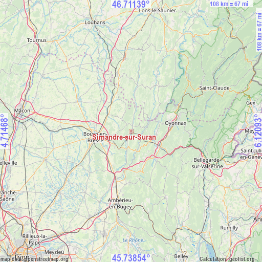
Simandre-sur-Suran GPS coordinates[2]
46° 13' 37.632" North, 5° 25' 4.08" East
| Map corner | latitude | longitude |
|---|---|---|
| Upper-left | 46.71139°, | 4.71468° |
| Center: | 46.22712°, | 5.4178° |
| Lower-right: | 45.73854°, | 6.12093° |
| Map W x H: | 108.2×108.2 km | = 67.2×67.2mi |
| max Lat: | 51.07786° ⇑63.2% North |
| Simandre-sur-Suran: | 46.22712° |
| min Lat: | ⇓36.8% South 41.3874° |
| min Long | Simandre-sur-Su | max Long |
| -5.08615° | 5.4178° | 9.52242° |
| W 82.2%⇐ | ⇒17.8% E |
Elevation
Elevation of Simandre-sur-Suran is 310 m = 1017 ft, and this is 116.3 m = 382 ft above average elevation for this country.
| Max E: |
2333 m = 7654 ft | 18.1% |
| Simandre-sur-Suran | 310 m 1017 ft | |
| Avg. | 193.7 m = 635 ft | |
Min E: |
-1 m = -3 ft | 81.9% |
See also: France elevation on elevation.city.
Geographical zone
Simandre-sur-Suran is located in North temperate zone (between Tropic of Cancer and the Arctic Circle). Distance of this North polar circle is 2261.2 km =1405 mi to North.| Distance of | km | miles | from Simandre-sur-Suran |
|---|---|---|---|
| North Pole | 4867.1 | 3024.3 | to North |
| Arctic Circle | 2261.2 | 1405 | to North |
| Tropic Cancer | 2534.1 | 1574.6 | to South |
| Equator | 5140 | 3193.8 | to South |


Nearby cities:
15 places around Simandre-sur-Suran: (largest is in red/bold)
• Aromas
8.8 km =5.5 mi,  33°
33°
• Bohas-Meyriat-Rignat
7.8 km =4.8 mi,  196°
196°
• Ceyzériat
9.1 km =5.7 mi,  235°
235°
• Chavannes-sur-Suran
4.1 km =2.5 mi,  10°
10°
• Corveissiat
5.3 km =3.3 mi,  68°
68°
• Cuisiat
8.4 km =5.2 mi,  344°
344°
• Granges
6.3 km =3.9 mi,  78°
78°
• Hautecourt-Romanèche
7.4 km =4.6 mi,  180°
180°
• Izernore
10.4 km =6.5 mi,  98°
98°
• Jasseron
7.2 km =4.5 mi,  257°
257°
• Meillonnas
5.5 km =3.4 mi,  289°
289°
• Revonnas
9.7 km =6 mi,  224°
224°
• Thoirette
9.8 km =6.1 mi,  60°
60°
• Treffort-Cuisiat
5.9 km =3.7 mi,  318°
318°
• Villereversure
5.4 km =3.4 mi,  210°
210°
Sources, notices
• [Note1] Compared only with cities in France existing in our database
• [Src1] Map data: © OpenStreetMap contributors (CC-BY-SA)
• [Src2] Other city data from geonames.org with taken over terms of usage.
• [Src3] Geographical zone / Annual Mean Temperature by Robert A. Rohde @ Wikipedia
