Aromas geodata
Aromas (Bourgogne-Franche-Comté) is a populated place; located in France in Europe/Paris (GMT+2) time zone. With population of 508 people, there are 15076 cities with bigger population in this country. Compared to other cities in France, 62.4% of cities are located further ↑North; 82.7% of cities are located further ←West and 92% of cities have lower elevation than Aromas. Note1
Administrative division(s):
- Level 1: Bourgogne-Franche-Comté
- Level 2: Jura
- Level 3: Arrondissement de Lons-le-Saunier
- Level 4: Aromas


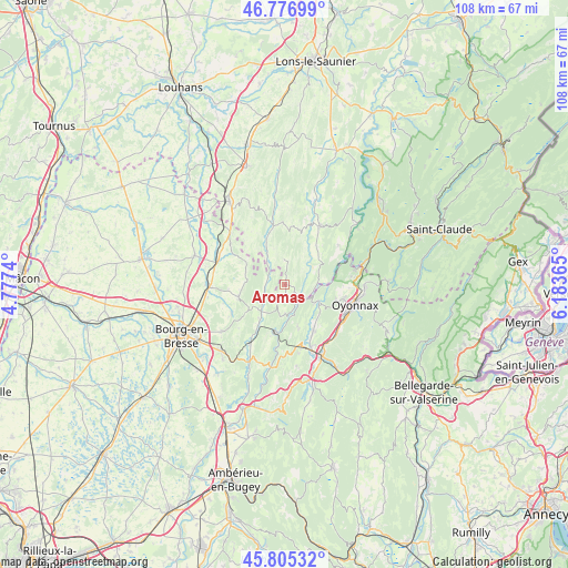
Aromas GPS coordinates[2]
46° 17' 35.916" North, 5° 28' 49.908" East
| Map corner | latitude | longitude |
|---|---|---|
| Upper-left | 46.77699°, | 4.7774° |
| Center: | 46.29331°, | 5.48053° |
| Lower-right: | 45.80532°, | 6.18365° |
| Map W x H: | 108×108 km | = 67.1×67.1mi |
| max Lat: | 51.07786° ⇑62.4% North |
| Aromas: | 46.29331° |
| min Lat: | ⇓37.6% South 41.3874° |
| min Long | Aromas | max Long |
| -5.08615° | 5.48053° | 9.52242° |
| W 82.7%⇐ | ⇒17.3% E |
Elevation
Elevation of Aromas is 475 m = 1558 ft, and this is 281.3 m = 923 ft above average elevation for this country.
| Max E: |
2333 m = 7654 ft | 8% |
| Aromas | 475 m 1558 ft | |
| Avg. | 193.7 m = 635 ft | |
Min E: |
-1 m = -3 ft | 92% |
See also: France elevation on elevation.city.
Geographical zone
Aromas is located in North temperate zone (between Tropic of Cancer and the Arctic Circle). Distance of this North polar circle is 2253.8 km =1400.4 mi to North.| Distance of | km | miles | from Aromas |
|---|---|---|---|
| North Pole | 4859.7 | 3019.7 | to North |
| Arctic Circle | 2253.8 | 1400.4 | to North |
| Tropic Cancer | 2541.4 | 1579.2 | to South |
| Equator | 5147.3 | 3198.4 | to South |


Nearby cities:
15 places around Aromas: (largest is in red/bold)
• Arinthod
12.9 km =8 mi,  30°
30°
• Bellignat
12.7 km =7.9 mi,  116°
116°
• Béard-Géovreissiat
12.8 km =8 mi,  155°
155°
• Chavannes-sur-Suran
5.2 km =3.2 mi,  230°
230°
• Corveissiat
5.4 km =3.4 mi,  178°
178°
• Cuisiat
7.1 km =4.4 mi,  276°
276°
• Granges
6.2 km =3.9 mi,  167°
167°
• Groissiat
12.6 km =7.8 mi,  128°
128°
• Géovreisset
11.4 km =7.1 mi,  111°
111°
• Izernore
10.4 km =6.5 mi,  148°
148°
• Martignat
13.6 km =8.5 mi, 132°
• Meillonnas
11.4 km =7.1 mi,  241°
241°
• Simandre-sur-Suran
8.8 km =5.5 mi,  213°
213°
• Thoirette
4.6 km =2.9 mi, 124°
• Treffort-Cuisiat
9.2 km =5.7 mi,  251°
251°
Sources, notices
• [Note1] Compared only with cities in France existing in our database
• [Src1] Map data: © OpenStreetMap contributors (CC-BY-SA)
• [Src2] Other city data from geonames.org with taken over terms of usage.
• [Src3] Geographical zone / Annual Mean Temperature by Robert A. Rohde @ Wikipedia
