Heuringhem geodata
Heuringhem (Hauts-de-France) is a populated place; located in France in Europe/Paris (GMT+2) time zone. With population of 1,327 people, there are 6906 cities with bigger population in this country. Compared to other cities in France, 98.8% of cities are located further ↓South; 53% of cities are located further →East and 84.5% of cities have higher elevation than Heuringhem. Note1
Administrative division(s):
- Level 1: Hauts-de-France
- Level 2: Pas-de-Calais
- Level 3: Arrondissement de Saint-Omer
- Level 4: Heuringhem


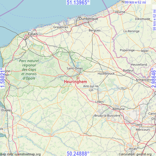
Heuringhem GPS coordinates[2]
50° 41' 46.968" North, 2° 16' 59.988" East
| Map corner | latitude | longitude |
|---|---|---|
| Upper-left | 51.13965°, | 1.58021° |
| Center: | 50.69638°, | 2.28333° |
| Lower-right: | 50.24888°, | 2.98646° |
| Map W x H: | 99×99 km | = 61.5×61.5mi |
| max Lat: | 51.07786° ⇑1.2% North |
| Heuringhem: | 50.69638° |
| min Lat: | ⇓98.8% South 41.3874° |
| min Long | Heuringhem | max Long |
| -5.08615° | 2.28333° | 9.52242° |
| W 47%⇐ | ⇒53% E |
Elevation
Elevation of Heuringhem is 43 m = 141 ft, and this is 150.7 m = 494 ft below average elevation for this country.
| Max E: |
2333 m = 7654 ft | 84.5% |
| Avg. | 193.7 m = 635 ft | |
| Heuringhem | 43 m = 141 ft | |
Min E: |
-1 m = -3 ft | 15.5% |
See also: France elevation on elevation.city.
Geographical zone
Heuringhem is located in North temperate zone (between Tropic of Cancer and the Arctic Circle). Distance of this North polar circle is 1764.3 km =1096.3 mi to North.| Distance of | km | miles | from Heuringhem |
|---|---|---|---|
| North Pole | 4370.2 | 2715.5 | to North |
| Arctic Circle | 1764.3 | 1096.3 | to North |
| Tropic Cancer | 3031 | 1883.4 | to South |
| Equator | 5636.9 | 3502.6 | to South |


Nearby cities:
15 places around Heuringhem: (largest is in red/bold)
• Arques
4.4 km =2.7 mi,  17°
17°
• Blendecques
2.5 km =1.6 mi,  4°
4°
• Campagne-lès-Wardrecques
4.4 km =2.7 mi,  54°
54°
• Ecques
2.9 km =1.8 mi,  175°
175°
• Esquerdes
6.7 km =4.2 mi,  277°
277°
• Hallines
4.3 km =2.7 mi,  291°
291°
• Helfaut
2.9 km =1.8 mi,  273°
273°
• Longuenesse
5.4 km =3.4 mi,  320°
320°
• Pihem
5.1 km =3.2 mi,  253°
253°
• Quiestède
3.9 km =2.4 mi,  116°
116°
• Racquinghem
5.2 km =3.2 mi,  94°
94°
• Roquetoire
5.1 km =3.2 mi, 124°
• Saint-Omer
6 km =3.7 mi,  344°
344°
• Wardrecques
4.6 km =2.9 mi,  69°
69°
• Wizernes
3.3 km =2.1 mi,  301°
301°
Sources, notices
• [Note1] Compared only with cities in France existing in our database
• [Src1] Map data: © OpenStreetMap contributors (CC-BY-SA)
• [Src2] Other city data from geonames.org with taken over terms of usage.
• [Src3] Geographical zone / Annual Mean Temperature by Robert A. Rohde @ Wikipedia
