Tende geodata
Tende (Provence-Alpes-Côte d'Azur) is a populated place; located in France in Europe/Paris (GMT+2) time zone. With population of 1,953 people, there are 4904 cities with bigger population in this country. Compared to other cities in France, 86.3% of cities are located further ↑North; 98.5% of cities are located further ←West and 99.3% of cities have lower elevation than Tende. Note1
Administrative division(s):
- Level 1: Provence-Alpes-Côte d'Azur
- Level 2: Alpes-Maritimes
- Level 3: Arrondissement de Nice
- Level 4: Tende


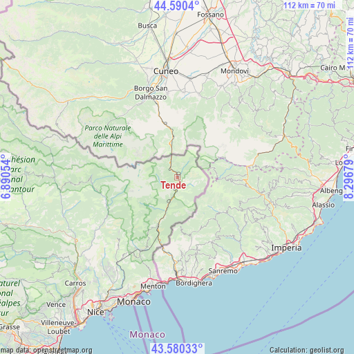
Tende GPS coordinates[2]
44° 5' 15.072" North, 7° 35' 37.176" East
| Map corner | latitude | longitude |
|---|---|---|
| Upper-left | 44.5904°, | 6.89054° |
| Center: | 44.08752°, | 7.59366° |
| Lower-right: | 43.58033°, | 8.29679° |
| Map W x H: | 112.3×112.3 km | = 69.8×69.8mi |
| max Lat: | 51.07786° ⇑86.3% North |
| Tende: | 44.08752° |
| min Lat: | ⇓13.7% South 41.3874° |
| min Long | Tende | max Long |
| -5.08615° | 7.59366° | 9.52242° |
| W 98.5%⇐ | ⇒1.5% E |
Elevation
Elevation of Tende is 1061 m = 3481 ft, and this is 867.3 m = 2845 ft above average elevation for this country.
| Max E: |
2333 m = 7654 ft | 0.7% |
| Tende | 1061 m 3481 ft | |
| Avg. | 193.7 m = 635 ft | |
Min E: |
-1 m = -3 ft | 99.3% |
See also: France elevation on elevation.city.
Geographical zone
Tende is located in North temperate zone (between Tropic of Cancer and the Arctic Circle). Distance of this Northern Tropic circle is 2296.2 km =1426.8 mi to South.| Distance of | km | miles | from Tende |
|---|---|---|---|
| North Pole | 5105 | 3172.1 | to North |
| Arctic Circle | 2499.1 | 1552.9 | to North |
| Tropic Cancer | 2296.2 | 1426.8 | to South |
| Equator | 4902.1 | 3046 | to South |


Nearby cities:
15 places around Tende: (largest is in red/bold)
• Belvédère
23.2 km =14.4 mi,  249°
249°
• Breil-sur-Roya
17.8 km =11.1 mi,  200°
200°
• Castellar
32.5 km =20.2 mi,  193°
193°
• Coaraze
34.5 km =21.4 mi,  223°
223°
• Gorbio
35.5 km =22.1 mi, 199°
• Lantosque
25.8 km =16 mi,  240°
240°
• Lucéram
29.4 km =18.3 mi, 219°
• L’Escarène
33.9 km =21.1 mi,  214°
214°
• Menton
35.3 km =21.9 mi, 191°
• Peille
35.2 km =21.9 mi, 205°
• Roquebillière
24.4 km =15.2 mi, 249°
• Saint-Martin-Vésubie
27.1 km =16.8 mi,  265°
265°
• Sainte-Agnès
33.6 km =20.9 mi, 198°
• Sospel
26.1 km =16.2 mi, 206°
• Utelle
33.5 km =20.8 mi, 235°
Sources, notices
• [Note1] Compared only with cities in France existing in our database
• [Src1] Map data: © OpenStreetMap contributors (CC-BY-SA)
• [Src2] Other city data from geonames.org with taken over terms of usage.
• [Src3] Geographical zone / Annual Mean Temperature by Robert A. Rohde @ Wikipedia
