Régusse geodata
Régusse (Provence-Alpes-Côte d'Azur) is a populated place; located in France in Europe/Paris (GMT+2) time zone. With population of 1,227 people, there are 7399 cities with bigger population in this country. Compared to other cities in France, 91.1% of cities are located further ↑North; 88.6% of cities are located further ←West and 93.4% of cities have lower elevation than Régusse. Note1
Administrative division(s):
- Level 1: Provence-Alpes-Côte d'Azur
- Level 2: Var
- Level 3: Arrondissement de Brignoles
- Level 4: Régusse


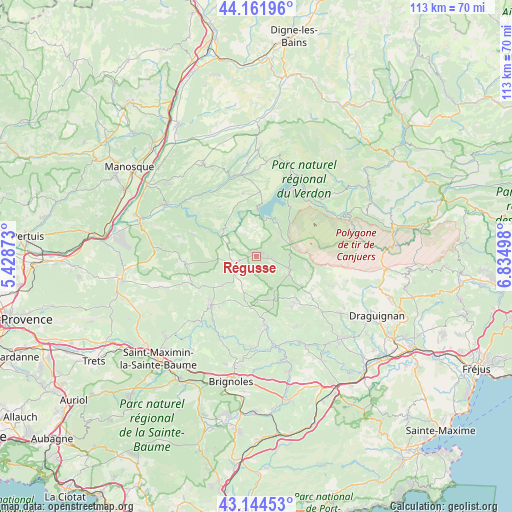
Régusse GPS coordinates[2]
43° 39' 19.44" North, 6° 7' 54.696" East
| Map corner | latitude | longitude |
|---|---|---|
| Upper-left | 44.16196°, | 5.42873° |
| Center: | 43.6554°, | 6.13186° |
| Lower-right: | 43.14453°, | 6.83498° |
| Map W x H: | 113.1×113.1 km | = 70.3×70.3mi |
| max Lat: | 51.07786° ⇑91.1% North |
| Régusse: | 43.6554° |
| min Lat: | ⇓8.9% South 41.3874° |
| min Long | Régusse | max Long |
| -5.08615° | 6.13186° | 9.52242° |
| W 88.6%⇐ | ⇒11.4% E |
Elevation
Elevation of Régusse is 520 m = 1706 ft, and this is 326.3 m = 1071 ft above average elevation for this country.
| Max E: |
2333 m = 7654 ft | 6.6% |
| Régusse | 520 m 1706 ft | |
| Avg. | 193.7 m = 635 ft | |
Min E: |
-1 m = -3 ft | 93.4% |
See also: France elevation on elevation.city.
Geographical zone
Régusse is located in North temperate zone (between Tropic of Cancer and the Arctic Circle). Distance of this Northern Tropic circle is 2248.1 km =1396.9 mi to South.| Distance of | km | miles | from Régusse |
|---|---|---|---|
| North Pole | 5153 | 3201.9 | to North |
| Arctic Circle | 2547.1 | 1582.7 | to North |
| Tropic Cancer | 2248.1 | 1396.9 | to South |
| Equator | 4854 | 3016.1 | to South |


Nearby cities:
15 places around Régusse: (largest is in red/bold)
• Aups
8.1 km =5 mi,  111°
111°
• Barjols
14.7 km =9.1 mi,  222°
222°
• Cotignac
14.2 km =8.8 mi,  174°
174°
• Entrecasteaux
17.9 km =11.1 mi,  150°
150°
• La Verdière
16 km =9.9 mi,  263°
263°
• Pontevès
14 km =8.7 mi, 216°
• Riez
18.4 km =11.4 mi,  350°
350°
• Roumoules
18.9 km =11.7 mi,  359°
359°
• Saint-Julien
18.5 km =11.5 mi,  282°
282°
• Salernes
13.1 km =8.1 mi,  141°
141°
• Sillans-la-Cascade
10.5 km =6.5 mi,  158°
158°
• Tavernes
11.5 km =7.1 mi,  233°
233°
• Tourtour
15.6 km =9.7 mi,  118°
118°
• Varages
15.3 km =9.5 mi,  245°
245°
• Villecroze
14.2 km =8.8 mi,  125°
125°
Sources, notices
• [Note1] Compared only with cities in France existing in our database
• [Src1] Map data: © OpenStreetMap contributors (CC-BY-SA)
• [Src2] Other city data from geonames.org with taken over terms of usage.
• [Src3] Geographical zone / Annual Mean Temperature by Robert A. Rohde @ Wikipedia
