Aups geodata
Aups (Provence-Alpes-Côte d'Azur) is a populated place; located in France in Europe/Paris (GMT+2) time zone. With population of 2,113 people, there are 4560 cities with bigger population in this country. Compared to other cities in France, 91.5% of cities are located further ↑North; 89.5% of cities are located further ←West and 93.2% of cities have lower elevation than Aups. Note1
Administrative division(s):
- Level 1: Provence-Alpes-Côte d'Azur
- Level 2: Var
- Level 3: Arrondissement de Brignoles
- Level 4: Aups


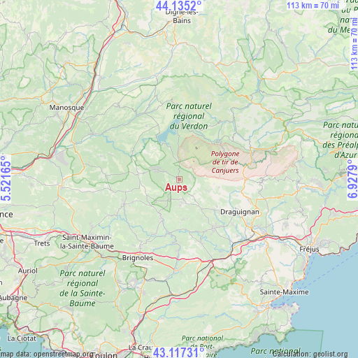
Aups GPS coordinates[2]
43° 37' 42.276" North, 6° 13' 29.172" East
| Map corner | latitude | longitude |
|---|---|---|
| Upper-left | 44.1352°, | 5.52165° |
| Center: | 43.62841°, | 6.22477° |
| Lower-right: | 43.11731°, | 6.9279° |
| Map W x H: | 113.2×113.2 km | = 70.3×70.3mi |
| max Lat: | 51.07786° ⇑91.5% North |
| Aups: | 43.62841° |
| min Lat: | ⇓8.5% South 41.3874° |
| min Long | Aups | max Long |
| -5.08615° | 6.22477° | 9.52242° |
| W 89.5%⇐ | ⇒10.5% E |
Elevation
Elevation of Aups is 514 m = 1686 ft, and this is 320.3 m = 1051 ft above average elevation for this country.
| Max E: |
2333 m = 7654 ft | 6.8% |
| Aups | 514 m 1686 ft | |
| Avg. | 193.7 m = 635 ft | |
Min E: |
-1 m = -3 ft | 93.2% |
See also: France elevation on elevation.city.
Geographical zone
Aups is located in North temperate zone (between Tropic of Cancer and the Arctic Circle). Distance of this Northern Tropic circle is 2245.1 km =1395 mi to South.| Distance of | km | miles | from Aups |
|---|---|---|---|
| North Pole | 5156 | 3203.8 | to North |
| Arctic Circle | 2550.1 | 1584.6 | to North |
| Tropic Cancer | 2245.1 | 1395 | to South |
| Equator | 4851 | 3014.3 | to South |


Nearby cities:
15 places around Aups: (largest is in red/bold)
• Ampus
12.9 km =8 mi,  100°
100°
• Barjols
19.2 km =11.9 mi,  245°
245°
• Carcès
17.3 km =10.7 mi,  191°
191°
• Cotignac
12.6 km =7.8 mi,  208°
208°
• Entrecasteaux
12.6 km =7.8 mi,  173°
173°
• Flayosc
17.4 km =10.8 mi,  127°
127°
• Lorgues
18.6 km =11.6 mi,  143°
143°
• Montfort-sur-Argens
19.2 km =11.9 mi, 206°
• Pontevès
17.8 km =11.1 mi,  242°
242°
• Régusse
8.1 km =5 mi,  291°
291°
• Salernes
7.3 km =4.5 mi, 174°
• Sillans-la-Cascade
7.7 km =4.8 mi, 208°
• Tavernes
17.2 km =10.7 mi,  257°
257°
• Tourtour
7.6 km =4.7 mi,  124°
124°
• Villecroze
6.6 km =4.1 mi, 141°
Sources, notices
• [Note1] Compared only with cities in France existing in our database
• [Src1] Map data: © OpenStreetMap contributors (CC-BY-SA)
• [Src2] Other city data from geonames.org with taken over terms of usage.
• [Src3] Geographical zone / Annual Mean Temperature by Robert A. Rohde @ Wikipedia
