Tartas geodata
Tartas (Nouvelle-Aquitaine) is a populated place; located in France in Europe/Paris (GMT+2) time zone. With population of 3,105 people, there are 3141 cities with bigger population in this country. Compared to other cities in France, 88.8% of cities are located further ↑North; 86.5% of cities are located further →East and 94.4% of cities have higher elevation than Tartas. Note1
Administrative division(s):
- Level 1: Nouvelle-Aquitaine
- Level 2: Landes
- Level 3: Arrondissement de Dax
- Level 4: Tartas


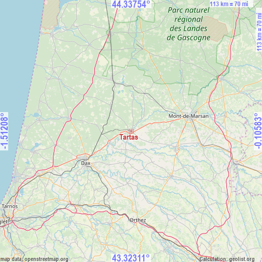
Tartas GPS coordinates[2]
43° 49' 56.928" North, 0° 48' 32.22" West
| Map corner | latitude | longitude |
|---|---|---|
| Upper-left | 44.33754°, | -1.51208° |
| Center: | 43.83248°, | -0.80895° |
| Lower-right: | 43.32311°, | -0.10583° |
| Map W x H: | 112.8×112.8 km | = 70.1×70.1mi |
| max Lat: | 51.07786° ⇑88.8% North |
| Tartas: | 43.83248° |
| min Lat: | ⇓11.2% South 41.3874° |
| min Long | Tartas | max Long |
| -5.08615° | -0.80895° | 9.52242° |
| W 13.5%⇐ | ⇒86.5% E |
Elevation
Elevation of Tartas is 19 m = 62 ft, and this is 174.7 m = 573 ft below average elevation for this country.
| Max E: |
2333 m = 7654 ft | 94.4% |
| Avg. | 193.7 m = 635 ft | |
| Tartas | 19 m = 62 ft | |
Min E: |
-1 m = -3 ft | 5.6% |
See also: France elevation on elevation.city.
Geographical zone
Tartas is located in North temperate zone (between Tropic of Cancer and the Arctic Circle). Distance of this Northern Tropic circle is 2267.8 km =1409.1 mi to South.| Distance of | km | miles | from Tartas |
|---|---|---|---|
| North Pole | 5133.3 | 3189.7 | to North |
| Arctic Circle | 2527.5 | 1570.5 | to North |
| Tropic Cancer | 2267.8 | 1409.1 | to South |
| Equator | 4873.7 | 3028.4 | to South |


Nearby cities:
15 places around Tartas: (largest is in red/bold)
• Aurice
16.5 km =10.3 mi,  96°
96°
• Bégaar
3.4 km =2.1 mi,  252°
252°
• Campagne
14.1 km =8.8 mi,  75°
75°
• Carcen-Ponson
5.5 km =3.4 mi,  1°
1°
• Gamarde-les-Bains
12.2 km =7.6 mi,  204°
204°
• Laluque
15.1 km =9.4 mi,  279°
279°
• Meilhan
9 km =5.6 mi,  66°
66°
• Montaut
16 km =9.9 mi,  129°
129°
• Montfort-en-Chalosse
13.7 km =8.5 mi,  190°
190°
• Mugron
10.3 km =6.4 mi,  153°
153°
• Pontonx-sur-l'Adour
10.6 km =6.6 mi,  241°
241°
• Poyanne
8.5 km =5.3 mi,  184°
184°
• Rion-des-Landes
14.6 km =9.1 mi,  320°
320°
• Souprosse
9.3 km =5.8 mi,  121°
121°
• Ygos-Saint-Saturnin
17 km =10.6 mi,  19°
19°
Sources, notices
• [Note1] Compared only with cities in France existing in our database
• [Src1] Map data: © OpenStreetMap contributors (CC-BY-SA)
• [Src2] Other city data from geonames.org with taken over terms of usage.
• [Src3] Geographical zone / Annual Mean Temperature by Robert A. Rohde @ Wikipedia
