Campagne geodata
Campagne (Nouvelle-Aquitaine) is a populated place; located in France in Europe/Paris (GMT+2) time zone. With population of 912 people, there are 9558 cities with bigger population in this country. Compared to other cities in France, 88.4% of cities are located further ↑North; 84.9% of cities are located further →East and 75.8% of cities have higher elevation than Campagne. Note1
Administrative division(s):
- Level 1: Nouvelle-Aquitaine
- Level 2: Landes
- Level 3: Arrondissement de Mont-de-Marsan
- Level 4: Campagne


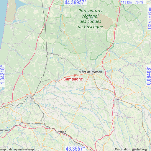
Campagne GPS coordinates[2]
43° 51' 53.244" North, 0° 38' 20.58" West
| Map corner | latitude | longitude |
|---|---|---|
| Upper-left | 44.36957°, | -1.34218° |
| Center: | 43.86479°, | -0.63905° |
| Lower-right: | 43.3557°, | 0.06408° |
| Map W x H: | 112.7×112.7 km | = 70×70mi |
| max Lat: | 51.07786° ⇑88.4% North |
| Campagne: | 43.86479° |
| min Lat: | ⇓11.6% South 41.3874° |
| min Long | Campagne | max Long |
| -5.08615° | -0.63905° | 9.52242° |
| W 15.1%⇐ | ⇒84.9% E |
Elevation
Elevation of Campagne is 65 m = 213 ft, and this is 128.7 m = 422 ft below average elevation for this country.
| Max E: |
2333 m = 7654 ft | 75.8% |
| Avg. | 193.7 m = 635 ft | |
| Campagne | 65 m = 213 ft | |
Min E: |
-1 m = -3 ft | 24.2% |
See also: France elevation on elevation.city.
Geographical zone
Campagne is located in North temperate zone (between Tropic of Cancer and the Arctic Circle). Distance of this Northern Tropic circle is 2271.4 km =1411.4 mi to South.| Distance of | km | miles | from Campagne |
|---|---|---|---|
| North Pole | 5129.8 | 3187.5 | to North |
| Arctic Circle | 2523.9 | 1568.3 | to North |
| Tropic Cancer | 2271.4 | 1411.4 | to South |
| Equator | 4877.3 | 3030.6 | to South |


Nearby cities:
15 places around Campagne: (largest is in red/bold)
• Aurice
6.3 km =3.9 mi,  153°
153°
• Benquet
11.7 km =7.3 mi,  109°
109°
• Bretagne-de-Marsan
14.1 km =8.8 mi,  97°
97°
• Carcen-Ponson
13.6 km =8.5 mi,  278°
278°
• Geloux
12.9 km =8 mi,  359°
359°
• Haut-Mauco
7.9 km =4.9 mi,  122°
122°
• Meilhan
5.4 km =3.4 mi,  269°
269°
• Mont-de-Marsan
11.7 km =7.3 mi,  76°
76°
• Montaut
13.9 km =8.6 mi,  185°
185°
• Saint-Perdon
3.9 km =2.4 mi,  88°
88°
• Saint-Pierre-du-Mont
9.6 km =6 mi, 76°
• Saint-Sever
13.1 km =8.1 mi,  156°
156°
• Souprosse
10.2 km =6.3 mi,  214°
214°
• Tartas
14.1 km =8.8 mi,  255°
255°
• Uchacq-et-Parentis
9.4 km =5.8 mi,  42°
42°
Sources, notices
• [Note1] Compared only with cities in France existing in our database
• [Src1] Map data: © OpenStreetMap contributors (CC-BY-SA)
• [Src2] Other city data from geonames.org with taken over terms of usage.
• [Src3] Geographical zone / Annual Mean Temperature by Robert A. Rohde @ Wikipedia
