Bégaar geodata
Bégaar (Nouvelle-Aquitaine) is a populated place; located in France in Europe/Paris (GMT+2) time zone. With population of 1,018 people, there are 8707 cities with bigger population in this country. Compared to other cities in France, 88.9% of cities are located further ↑North; 86.9% of cities are located further →East and 95.7% of cities have higher elevation than Bégaar. Note1
Administrative division(s):
- Level 1: Nouvelle-Aquitaine
- Level 2: Landes
- Level 3: Arrondissement de Dax
- Level 4: Bégaar


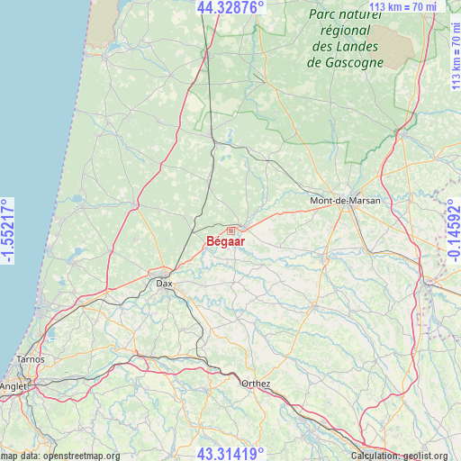
Bégaar GPS coordinates[2]
43° 49' 25.068" North, 0° 50' 56.544" West
| Map corner | latitude | longitude |
|---|---|---|
| Upper-left | 44.32876°, | -1.55217° |
| Center: | 43.82363°, | -0.84904° |
| Lower-right: | 43.31419°, | -0.14592° |
| Map W x H: | 112.8×112.8 km | = 70.1×70.1mi |
| max Lat: | 51.07786° ⇑88.9% North |
| Bégaar: | 43.82363° |
| min Lat: | ⇓11.1% South 41.3874° |
| min Long | Bégaar | max Long |
| -5.08615° | -0.84904° | 9.52242° |
| W 13.1%⇐ | ⇒86.9% E |
Elevation
Elevation of Bégaar is 15 m = 49 ft, and this is 178.7 m = 586 ft below average elevation for this country.
| Max E: |
2333 m = 7654 ft | 95.7% |
| Avg. | 193.7 m = 635 ft | |
| Bégaar | 15 m = 49 ft | |
Min E: |
-1 m = -3 ft | 4.3% |
See also: France elevation on elevation.city.
Geographical zone
Bégaar is located in North temperate zone (between Tropic of Cancer and the Arctic Circle). Distance of this Northern Tropic circle is 2266.8 km =1408.5 mi to South.| Distance of | km | miles | from Bégaar |
|---|---|---|---|
| North Pole | 5134.3 | 3190.3 | to North |
| Arctic Circle | 2528.4 | 1571.1 | to North |
| Tropic Cancer | 2266.8 | 1408.5 | to South |
| Equator | 4872.7 | 3027.8 | to South |


Nearby cities:
15 places around Bégaar: (largest is in red/bold)
• Candresse
16 km =9.9 mi,  220°
220°
• Carcen-Ponson
7.3 km =4.5 mi,  27°
27°
• Gamarde-les-Bains
10.3 km =6.4 mi,  190°
190°
• Hinx
14.9 km =9.3 mi,  204°
204°
• Laluque
12.1 km =7.5 mi,  286°
286°
• Meilhan
12.3 km =7.6 mi,  68°
68°
• Montfort-en-Chalosse
12.5 km =7.8 mi,  176°
176°
• Mugron
11.4 km =7.1 mi,  136°
136°
• Pontonx-sur-l'Adour
7.3 km =4.5 mi,  236°
236°
• Poyanne
7.9 km =4.9 mi,  160°
160°
• Poyartin
15.4 km =9.6 mi, 185°
• Rion-des-Landes
13.7 km =8.5 mi,  334°
334°
• Saint-Vincent-de-Paul
15.4 km =9.6 mi, 235°
• Souprosse
11.8 km =7.3 mi,  109°
109°
• Tartas
3.4 km =2.1 mi, 72°
Sources, notices
• [Note1] Compared only with cities in France existing in our database
• [Src1] Map data: © OpenStreetMap contributors (CC-BY-SA)
• [Src2] Other city data from geonames.org with taken over terms of usage.
• [Src3] Geographical zone / Annual Mean Temperature by Robert A. Rohde @ Wikipedia
