Rion-des-Landes geodata
Rion-des-Landes (Nouvelle-Aquitaine) is a populated place; located in France in Europe/Paris (GMT+2) time zone. With population of 2,401 people, there are 4029 cities with bigger population in this country. Compared to other cities in France, 87.7% of cities are located further ↑North; 87.5% of cities are located further →East and 74.6% of cities have higher elevation than Rion-des-Landes. Note1
Administrative division(s):
- Level 1: Nouvelle-Aquitaine
- Level 2: Landes
- Level 3: Arrondissement de Dax
- Level 4: Rion-des-Landes


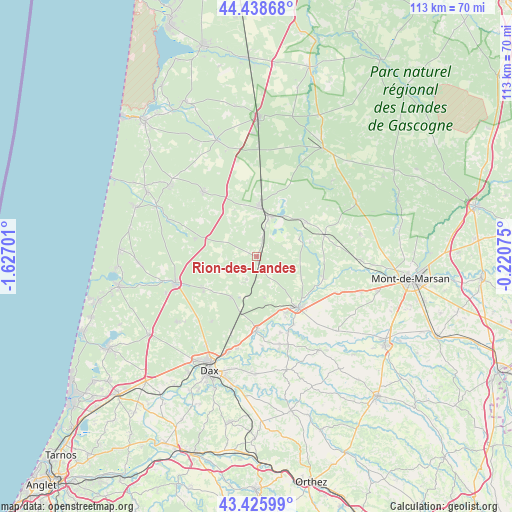
Rion-des-Landes GPS coordinates[2]
43° 56' 4.164" North, 0° 55' 25.968" West
| Map corner | latitude | longitude |
|---|---|---|
| Upper-left | 44.43868°, | -1.62701° |
| Center: | 43.93449°, | -0.92388° |
| Lower-right: | 43.42599°, | -0.22075° |
| Map W x H: | 112.6×112.6 km | = 70×70mi |
| max Lat: | 51.07786° ⇑87.7% North |
| Rion-des-Landes: | 43.93449° |
| min Lat: | ⇓12.3% South 41.3874° |
| min Long | Rion-des-Landes | max Long |
| -5.08615° | -0.92388° | 9.52242° |
| W 12.5%⇐ | ⇒87.5% E |
Elevation
Elevation of Rion-des-Landes is 68 m = 223 ft, and this is 125.7 m = 412 ft below average elevation for this country.
| Max E: |
2333 m = 7654 ft | 74.6% |
| Avg. | 193.7 m = 635 ft | |
| Rion-des-Landes | 68 m = 223 ft | |
Min E: |
-1 m = -3 ft | 25.4% |
See also: France elevation on elevation.city.
Geographical zone
Rion-des-Landes is located in North temperate zone (between Tropic of Cancer and the Arctic Circle). Distance of this Northern Tropic circle is 2279.1 km =1416.2 mi to South.| Distance of | km | miles | from Rion-des-Landes |
|---|---|---|---|
| North Pole | 5122 | 3182.7 | to North |
| Arctic Circle | 2516.1 | 1563.4 | to North |
| Tropic Cancer | 2279.1 | 1416.2 | to South |
| Equator | 4885.1 | 3035.5 | to South |


Nearby cities:
15 places around Rion-des-Landes: (largest is in red/bold)
• Arengosse
13.3 km =8.3 mi,  54°
54°
• Bégaar
13.7 km =8.5 mi,  154°
154°
• Carcen-Ponson
11 km =6.8 mi,  121°
121°
• Castets
18.7 km =11.6 mi,  251°
251°
• Herm
22.7 km =14.1 mi,  230°
230°
• Laluque
10.6 km =6.6 mi,  212°
212°
• Lesperon
14.1 km =8.8 mi,  286°
286°
• Meilhan
19.1 km =11.9 mi,  114°
114°
• Morcenx
11.2 km =7 mi,  4°
4°
• Onesse-Laharie
18.3 km =11.4 mi,  320°
320°
• Pontonx-sur-l'Adour
16.3 km =10.1 mi,  180°
180°
• Poyanne
21.6 km =13.4 mi,  156°
156°
• Saint-Vincent-de-Paul
22.2 km =13.8 mi,  197°
197°
• Tartas
14.6 km =9.1 mi,  140°
140°
• Ygos-Saint-Saturnin
15.6 km =9.7 mi,  72°
72°
Sources, notices
• [Note1] Compared only with cities in France existing in our database
• [Src1] Map data: © OpenStreetMap contributors (CC-BY-SA)
• [Src2] Other city data from geonames.org with taken over terms of usage.
• [Src3] Geographical zone / Annual Mean Temperature by Robert A. Rohde @ Wikipedia
