Aurice geodata
Aurice (Nouvelle-Aquitaine) is a populated place; located in France in Europe/Paris (GMT+2) time zone. With population of 683 people, there are 12036 cities with bigger population in this country. Compared to other cities in France, 89% of cities are located further ↑North; 84.5% of cities are located further →East and 71.9% of cities have higher elevation than Aurice. Note1
Administrative division(s):
- Level 1: Nouvelle-Aquitaine
- Level 2: Landes
- Level 3: Arrondissement de Mont-de-Marsan
- Level 4: Aurice


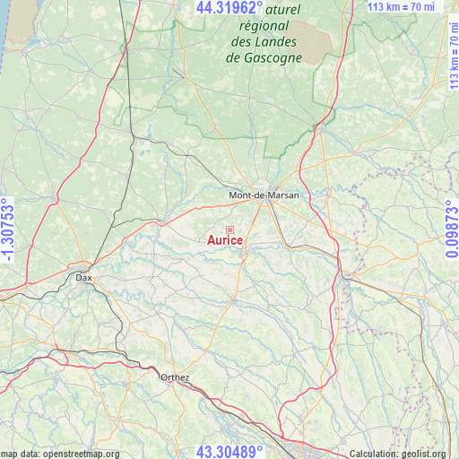
Aurice GPS coordinates[2]
43° 48' 51.876" North, 0° 36' 15.84" West
| Map corner | latitude | longitude |
|---|---|---|
| Upper-left | 44.31962°, | -1.30753° |
| Center: | 43.81441°, | -0.6044° |
| Lower-right: | 43.30489°, | 0.09873° |
| Map W x H: | 112.8×112.8 km | = 70.1×70.1mi |
| max Lat: | 51.07786° ⇑89% North |
| Aurice: | 43.81441° |
| min Lat: | ⇓11% South 41.3874° |
| min Long | Aurice | max Long |
| -5.08615° | -0.6044° | 9.52242° |
| W 15.5%⇐ | ⇒84.5% E |
Elevation
Elevation of Aurice is 74 m = 243 ft, and this is 119.7 m = 393 ft below average elevation for this country.
| Max E: |
2333 m = 7654 ft | 71.9% |
| Avg. | 193.7 m = 635 ft | |
| Aurice | 74 m = 243 ft | |
Min E: |
-1 m = -3 ft | 28.1% |
See also: France elevation on elevation.city.
Geographical zone
Aurice is located in North temperate zone (between Tropic of Cancer and the Arctic Circle). Distance of this Northern Tropic circle is 2265.8 km =1407.9 mi to South.| Distance of | km | miles | from Aurice |
|---|---|---|---|
| North Pole | 5135.4 | 3191 | to North |
| Arctic Circle | 2529.5 | 1571.8 | to North |
| Tropic Cancer | 2265.8 | 1407.9 | to South |
| Equator | 4871.7 | 3027.1 | to South |


Nearby cities:
15 places around Aurice: (largest is in red/bold)
• Benquet
8.5 km =5.3 mi,  78°
78°
• Bretagne-de-Marsan
11.8 km =7.3 mi,  71°
71°
• Campagne
6.3 km =3.9 mi,  333°
333°
• Haut-Mauco
4.2 km =2.6 mi, 70°
• Meilhan
9.9 km =6.2 mi,  304°
304°
• Mont-de-Marsan
12 km =7.5 mi,  45°
45°
• Montaut
9.2 km =5.7 mi,  206°
206°
• Montgaillard
12.6 km =7.8 mi,  129°
129°
• Montsoué
11.9 km =7.4 mi,  139°
139°
• Saint-Maurice-sur-Adour
11.5 km =7.1 mi,  106°
106°
• Saint-Perdon
5.8 km =3.6 mi,  10°
10°
• Saint-Pierre-du-Mont
10.2 km =6.3 mi,  40°
40°
• Saint-Sever
6.8 km =4.2 mi,  158°
158°
• Souprosse
9 km =5.6 mi,  251°
251°
• Uchacq-et-Parentis
13 km =8.1 mi,  15°
15°
Sources, notices
• [Note1] Compared only with cities in France existing in our database
• [Src1] Map data: © OpenStreetMap contributors (CC-BY-SA)
• [Src2] Other city data from geonames.org with taken over terms of usage.
• [Src3] Geographical zone / Annual Mean Temperature by Robert A. Rohde @ Wikipedia
