Les Trois-Pierres geodata
Les Trois-Pierres (Normandy) is a populated place; located in France in Europe/Paris (GMT+2) time zone. With population of 746 people, there are 11210 cities with bigger population in this country. Compared to other cities in France, 90% of cities are located further ↓South; 74.1% of cities are located further →East and 53.8% of cities have higher elevation than Les Trois-Pierres. Note1
Administrative division(s):
- Level 1: Normandy
- Level 2: Seine-Maritime
- Level 3: Arrondissement du Havre
- Level 4: Les Trois-Pierres


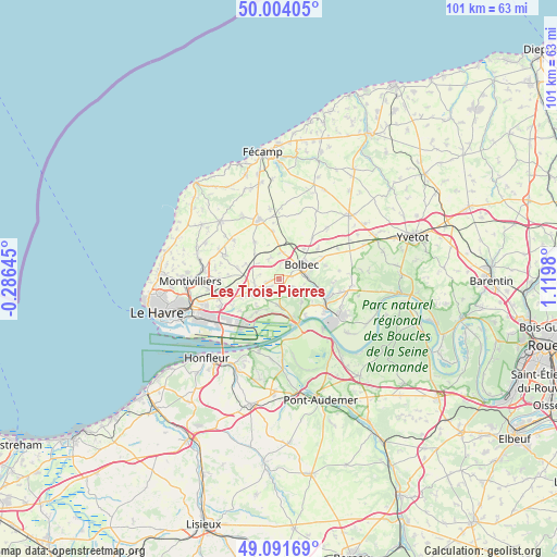
Les Trois-Pierres GPS coordinates[2]
49° 33' 0" North, 0° 25' 0.012" East
| Map corner | latitude | longitude |
|---|---|---|
| Upper-left | 50.00405°, | -0.28645° |
| Center: | 49.55°, | 0.41667° |
| Lower-right: | 49.09169°, | 1.1198° |
| Map W x H: | 101.4×101.4 km | = 63×63mi |
| max Lat: | 51.07786° ⇑10% North |
| Les Trois-Pierres: | 49.55° |
| min Lat: | ⇓90% South 41.3874° |
| min Long | Les Trois-Pierr | max Long |
| -5.08615° | 0.41667° | 9.52242° |
| W 25.9%⇐ | ⇒74.1% E |
Elevation
Elevation of Les Trois-Pierres is 120 m = 394 ft, and this is 73.7 m = 242 ft below average elevation for this country.
| Max E: |
2333 m = 7654 ft | 53.8% |
| Avg. | 193.7 m = 635 ft | |
| Les Trois-Pierres | 120 m = 394 ft | |
Min E: |
-1 m = -3 ft | 46.2% |
See also: France elevation on elevation.city.
Geographical zone
Les Trois-Pierres is located in North temperate zone (between Tropic of Cancer and the Arctic Circle). Distance of this North polar circle is 1891.7 km =1175.4 mi to North.| Distance of | km | miles | from Les Trois-Pierres |
|---|---|---|---|
| North Pole | 4497.6 | 2794.7 | to North |
| Arctic Circle | 1891.7 | 1175.4 | to North |
| Tropic Cancer | 2903.5 | 1804.2 | to South |
| Equator | 5509.4 | 3423.4 | to South |


Nearby cities:
15 places around Les Trois-Pierres: (largest is in red/bold)
• Beuzeville-la-Grenier
4.7 km =2.9 mi,  9°
9°
• Bolbec
4.8 km =3 mi,  57°
57°
• Gommerville
3.5 km =2.2 mi,  280°
280°
• Graimbouville
6.7 km =4.2 mi,  294°
294°
• Gruchet-le-Valasse
5.1 km =3.2 mi,  84°
84°
• La Cerlangue
4.9 km =3 mi,  182°
182°
• La Remuée
2.7 km =1.7 mi,  201°
201°
• Mélamare
3.1 km =1.9 mi,  117°
117°
• Nointot
6.9 km =4.3 mi,  38°
38°
• Saint-Antoine-la-Forêt
4.4 km =2.7 mi,  110°
110°
• Saint-Eustache-la-Forêt
2.8 km =1.7 mi,  86°
86°
• Saint-Gilles-de-la-Neuville
4.1 km =2.5 mi,  312°
312°
• Saint-Nicolas-de-la-Taille
6 km =3.7 mi,  136°
136°
• Saint-Romain-de-Colbosc
4.8 km =3 mi,  243°
243°
• Saint-Vincent-Cramesnil
6.6 km =4.1 mi,  217°
217°
Sources, notices
• [Note1] Compared only with cities in France existing in our database
• [Src1] Map data: © OpenStreetMap contributors (CC-BY-SA)
• [Src2] Other city data from geonames.org with taken over terms of usage.
• [Src3] Geographical zone / Annual Mean Temperature by Robert A. Rohde @ Wikipedia
